


The Robber Barons and the Reset

In this post, I am going to pull together research I have done in the past to show you the evidence I have found for what I believe has taken place here, and who was responsible for the world we live in today.

The corrupted world we live in today which was nothing like the incredibly advanced Moorish-Atlantean civilization that existed on Earth from ancient times to modern times when Humanity was functioning collectively at a much higher level of consciousness before it was destroyed, and not that long ago.

As I have said before, my working hypothesis is that the circuit board of the Earth’s original energy grid system was deliberately destroyed relatively recently by one or more forms of directed frequency or energy of some kind into different places on the Earth’s grid, causing the surface of the Earth to undulate and buckle.
What I am seeing from tracking leylines all over the Earth, looking from place-to-place at cities in alignment over long-distances, are the consistent presence of swamps, marshes, bogs, deserts, dunes, and places where it appears land masses sheared-off and submerged under the bodies of water we see today.

I believe the malevolent, parasitic beings behind the cataclysm were shovel-ready to dig enough of the original infrastructure out of the ruined Earth so they could be used and civilization restarted as the New World Order, which I think started in earnest in the mid-to-late 1700s and early 1800s.
There’s extensive underground infrastructure where those living on Earth at that time could have survived until the surface of the Earth was habitable.
Then they only used the pre-existing infrastructure until they found replacement fuel sources that could be monetized and controlled by them for what had originally been a free-energy power grid and transportation system worldwide, and when what remained of the original infrastructure was no longer useful to them, or inconvenient to their agenda, they had it destroyed, discontinued, or abandoned, typically in a very short time after it was said to have been constructed.

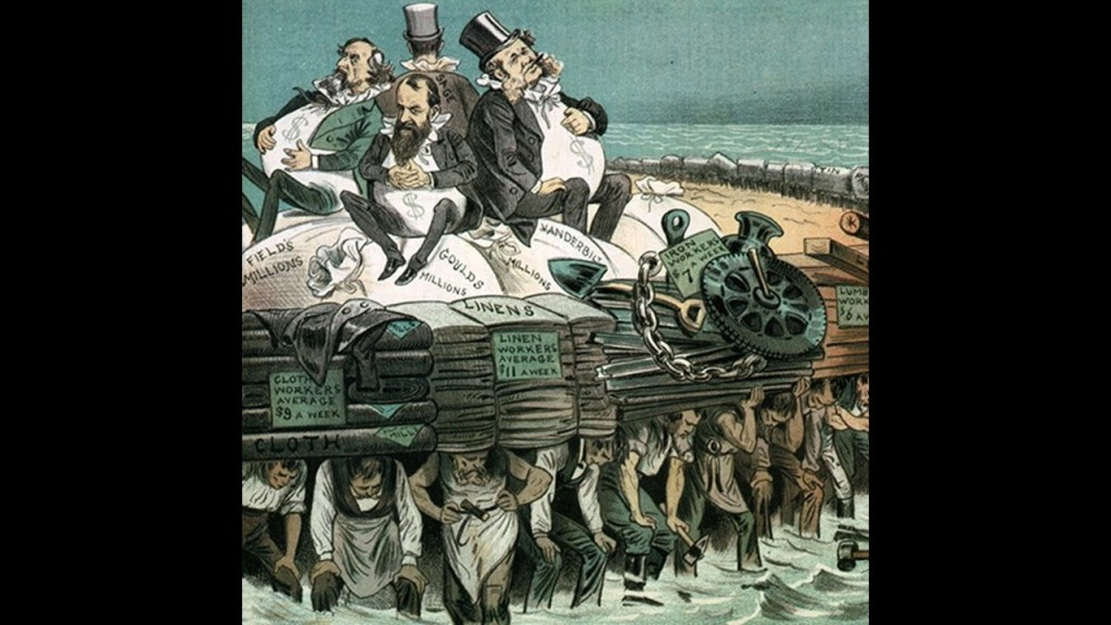
While this new parasitic self-styled elite class lived in the lap of luxury, and helped themselves to the best of everything, they had little care for anyone or anything else.

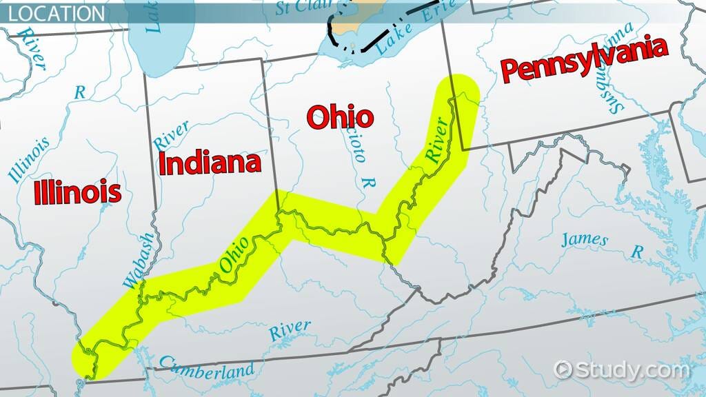
The same story repeats all over the country with the Robber Barons coming in and setting up shop and taking control of everything, starting first in Pennsylvania and then expanding their activities outward from there through Appalachia, the present-day Great Lakes Region and all the way across the continent.
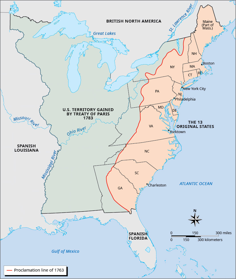
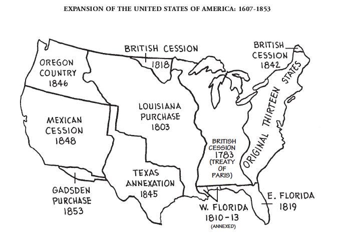
We learned in history class that this westward expansion was referred to as “Manifest Destiny,” a 19th-century belief that the United States was destined by God to expand its dominion across the entire continent.
But what if what we learn in school about our history is a complete and total fabrication, and something very different was going on here from what we have been taught to believe – not for the benefit of all, but only for the benefit of a very few?

As I just mentioned, the story of what happened here to create the New World Order starts first in Pennsylvania, so that is where I will begin.
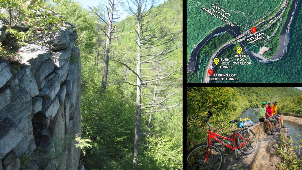
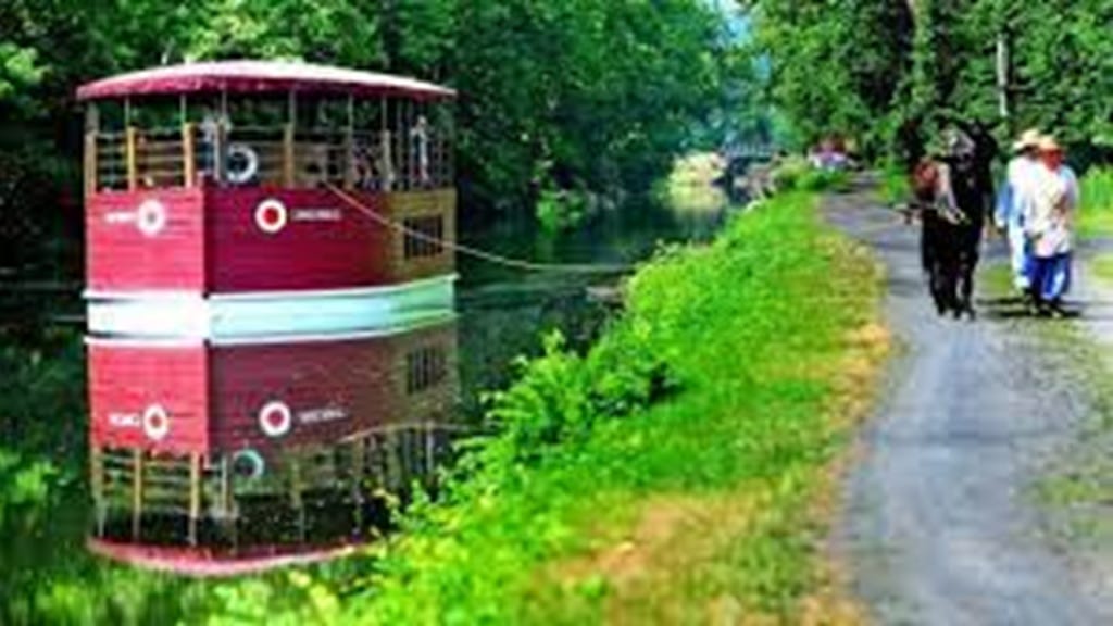
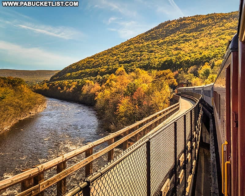
When I was doing research in 2024 for “On the Trail of Giants in Appalachia and Beyond,” I came across the Lehigh Gorge, its abandoned railroad tracks that are now a recreational rail-trail, and its Scenic Railway, and yet another place I can add to my list of places I know of off the top of my head featuring the co-location of S-shaped river bends, railroads, canals, gorges, and waterfalls that I have come to believe were part of the Earth’s original worldwide energy grid system.

The Lehigh Gorge is described as a “steep-walled gorge carved by a river, thick vegetation, rock-outcroppings, and waterfalls.”
The Lehigh Gorge Trail follows more than 20-miles, or 32-kilometers of the Delaware and Lehigh Trail, part of the larger Delaware and Lehigh National Heritage Corridor, which is 165-miles, or 266-kilometers, -long.
The Lehigh Gorge Trail is on abandoned railroad grade beside the river.
This is what we are told about the Delaware and Lehigh National Heritage Corridor by the National Park Service.
The Delaware and Lehigh National Heritage Corridor preserves the historic pathway that carried coal and iron from Wilkes-Barre to Philadelphia as a vital connection to nature, recreation and our nation’s industrial heritage, as well as having a more than $250-million per year economic impact for the region.
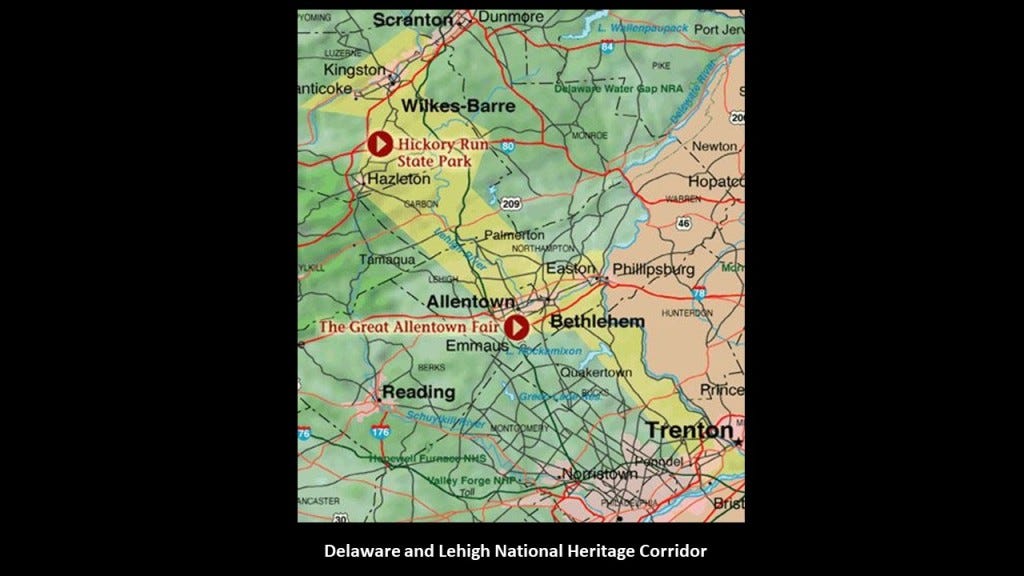
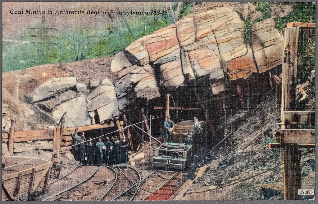
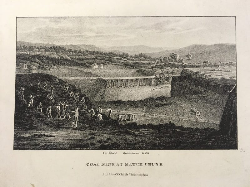
The Delaware and Lehigh National Heritage Corridor was also known as the “Anthracite Region” where the story of “where America was built” began.

What we are told about the Anthracite Region is this.
It was home at one time to major anthracite coal supplies and the mine-to-market process, with a legacy of intense mining, industrial development and rich mixture of ethnic cultures.
Anthracite coal was first mined in Wilkes-Barre in 1775, and we are told that it fueled urban development in the region, resulting in a string of towns, industries, mines, roads and rail-lines to the south.
It is interesting to note here that the Freiburg University of Mining and Technology, the oldest school of mining and metallurgy in the world, was established just 10-years prior to the beginning of anthracite coal-mining in Wilkes-Barre, having been established in 1765 by Francis Xavier of Saxony of the House of Wettin.
Its main purpose was the education of highly skilled miners and scientists in fields connected to mining and metallurgy.

Primarily through Queen Victoria and Prince Albert, first-cousins and members of the House of Saxe-Coburg and Gotha of the Ernestine branch of the House of Wettin, the original royal houses of Europe were completely replaced by this obscure German Ducal lineage.

Alexander von Humboldt was a graduate of the Freiburg University of Mining and Technology.
He was a Prussian naturalist who in our narrative was a pioneer of the fields of biogeography and geomagnetism, and an explorer of the Americas between 1799 and 1804, starting with an exploration of Mount Teide on Tenerife in the Canary Islands.

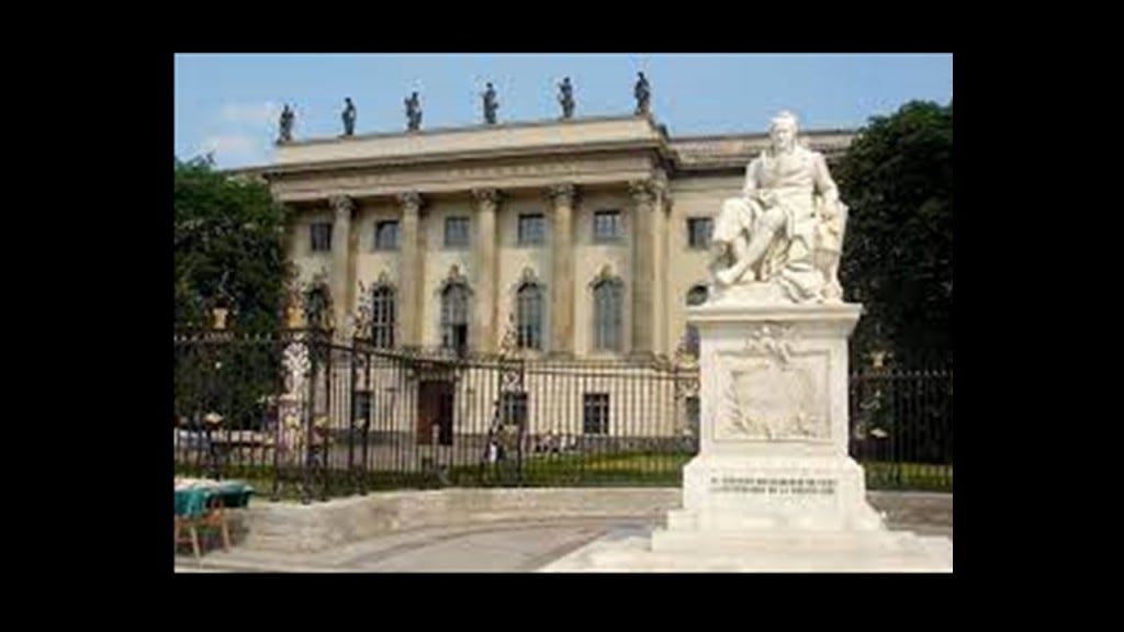
Humboldt University in Berlin was named after Alexander von Humboldt and his brother Wilhelm.
It was first opened in 1810, and was regarded as one of the world’s pre-eminent universities in the study of Natural Sciences in the 1800s and 1900s.
Famous faculty and alumni included such famous names in our current historical narrative, besides the previously mentioned Alfred Wegener of Continental Drift fame, include: the theoretical physicist Albert Einstein; Karl Marx and Friedrich Engels, c0-collaborators on “The Communist Manifesto;” Otto von Bismarck, first Chancellor of the German Empire; Georg Hegel, whose philosophy gave us the “Hegelian Dialectic” of Problem-Reaction-Solution; and the Brothers Grimm, best-known for their fairy tales which has such story-lines as eating people, as in “Little Red Riding Hood and “Hansel and Gretel.”
During the same time period as Alexander von Humboldt’s explorations were taking place between 1799 and 1804, the following historical events occurred as well.
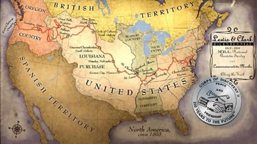
We are told the Louisiana Purchase was the acquisition of the Territory of Louisiana by the United States from France with the signing of the Louisiana Purchase Treaty on April 30th of 1803, which was officially announced on July 4th of 1803.
It was said to have doubled the size of the United States and paved the way for the nation’s westward expansion.
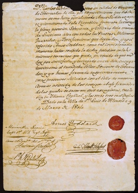
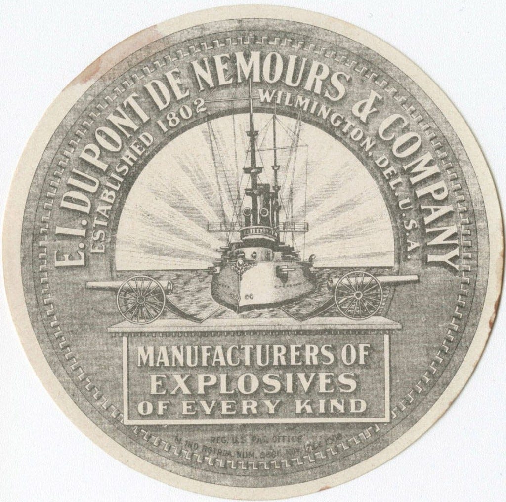
One of the negotiators with France for the terms of the Louisiana Purchase in 1803 on behalf of President Jefferson was the minor French nobleman Pierre Samuel Dupont de Nemours, who was living in the United States at the time.

His son Éleuthère Irénée du Pont, a chemist and industrialist, founded the E. I. du Pont de Nemours and Company to manufacture gunpowder and explosives in 1802, with the du Ponts becoming one of America’s richest families, with generations of influential businessmen, politicians and philanthropists.
The following year, in 1803, the Ames Shovel Shop was established in Easton, Massachusetts.
The Ames Shovel Shop became nationally known for providing the shovels for the Union Pacific Railroad, which opened the west. It was said to have been the world’s largest supplier of shovels in the 19th-century.
The Ames Brothers, Oakes and Oliver, Jr, co-owners of the shovel shop that was established by their father Oliver, were major players in the completion of the Union Pacific Railroad.

Also in 1803, the Lewis & Clark Expedition, also known as the Corps of Discovery, started on August 31, 1803 and lasted until September 25, 1806, with a mission to explore and map the newly acquired western portion of the country after the Louisiana Purchase.
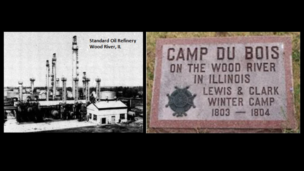
When I tracked the history of the entire Lewis and Clark Expedition in “Lewis and Clark & the Corps of Discovery – True History or Real Mystery,” not only did I find the Rockefellers and the Standard Oil Refinery in Wood River at the location of Camp Dubois on the Illinois side of the Mississippi River, near Cahokia Mounds, which was the official starting point of the Lewis and Clark expedition in 1804…
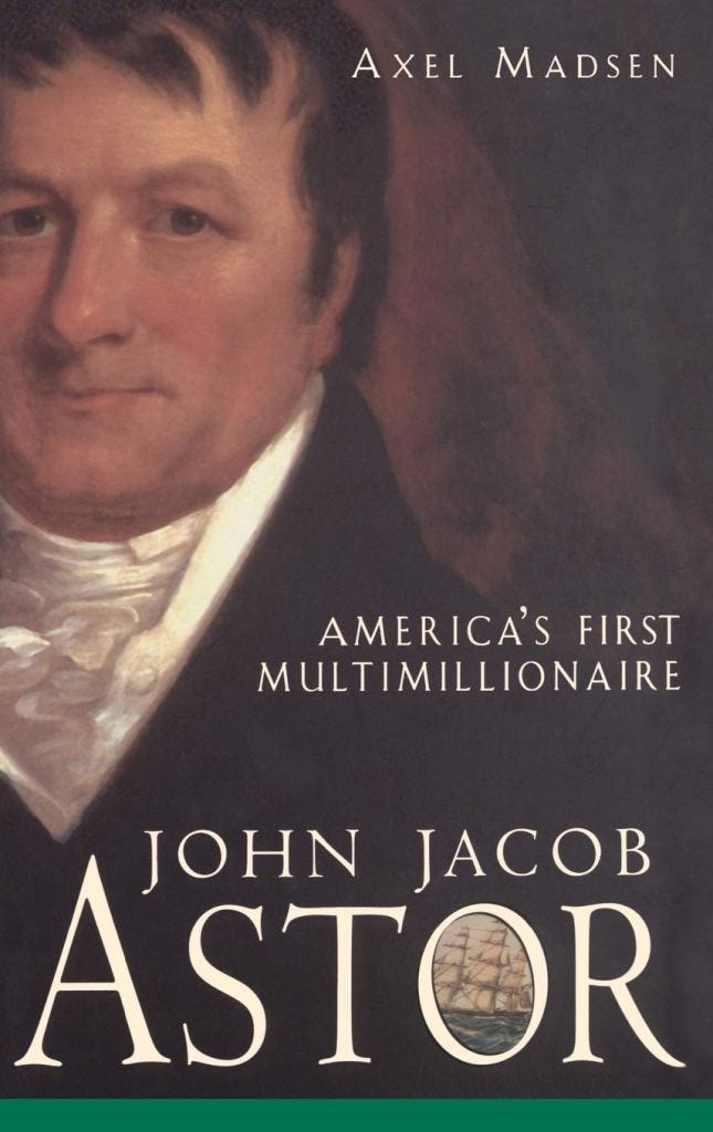
…and John Jacob Astor’s presence with the American Fur Company’s fur-trading fort at Fort Pierre, a stopping point of the Lewis and Clark Expedition in Sioux country in present-day South Dakota…
…I found the presence of other big names in the beginnings of the corporatocracy in which we have been living under, like the “General Mills” multinational manufacturer and marketer of ultraprocessed foods sold through retail stores.

Like I said earlier in this post, it is my belief that as soon as they were able to after this cataclysmic event took place, these bloodline families and their related-minions came into the ruined lands of the Earth to explore, claim, harvest the resources of, and provide us with a new history and their new systems for power and control of the Earth and its people after the worldwide energy grid of the Old World was destroyed in a deliberately-caused cataclysmic event.
They would have had an immediate need for explosives and shovels in a post-cataclysmic world of recent occurrence to begin their recovery work in order to bring their new civilization back on-line from the remnants of the old civilization.

Now back to the Anthracite Region in Pennsylvania.
We are told that the demand for anthracite coal increased in the 1820s and 1830s as coal-power replaced water power, and with the growth of the iron industry in Pennsylvania.
Anthracite coal is the purest form of coal, and this region contains most of the world’s supply of anthracite coal.

Today, this part of northeastern Pennsylvania is considered one of the largest concentrations of disturbed terrain in the world, with billions of tons of debris found in the landscape of abandoned strip mines and this region has among the highest poverty and unemployment rates in the United States with job loss from the decrease in coal mining and the outmigration of people because of it.

We are told the American Canal Age was between 1790 and 1855, and started in Pennsylvania, where the first legislation surveying canals was passed in 1762.
The construction of the Union Canal between Middletown and Reading in Pennsylvania was said to have started under the administration of President George Washington in 1792, and completed in 1828, and was touted as the “Golden Link” in providing an early transportation route for shipping anthracite coal and lumber to Philadelphia.
The “Main Line of Public Works,” of which the Union Canal was a part of, was passed by the Pennsylvania Legislature in 1826, and funded various transportation systems, including canal, road, and railroad.

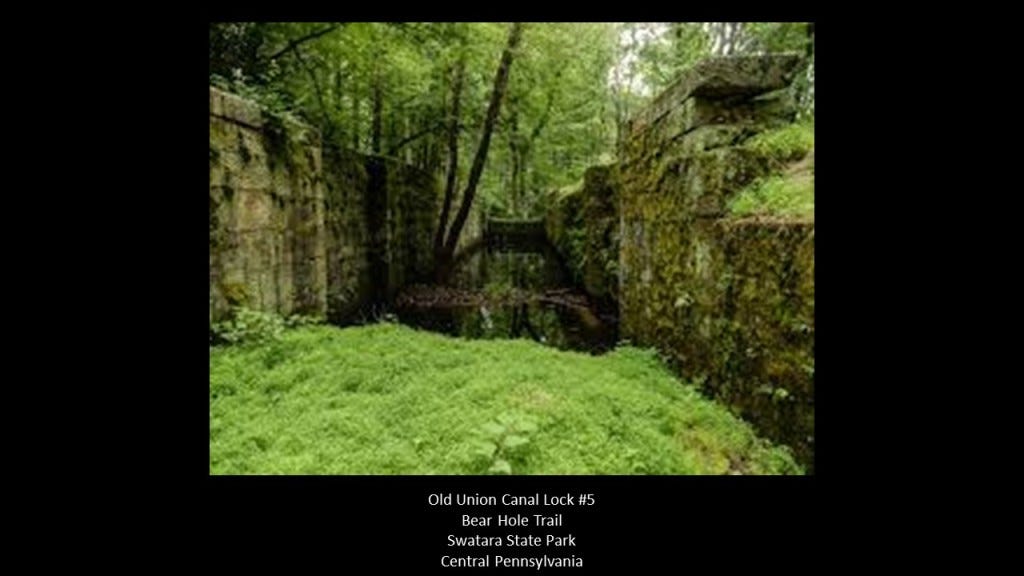
This is Lock #5 of the old Union Canal.
This section of the Union Canal was said to have been closed after the dam holding the reservoir was washed away by a devastating flood in 1862, and the rest of the Union Canal was said to have been closed to use in 1885 because it could not compete with the “efficiency of the railroad.”
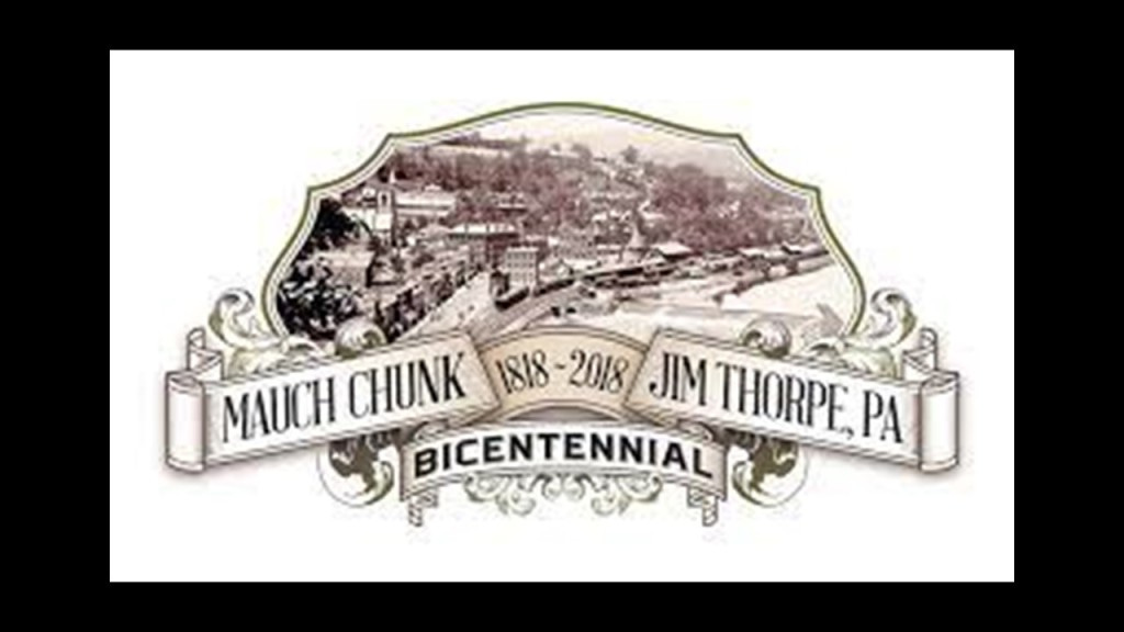
We are told the lower section of the Lehigh Canal was built between Easton, Pennsylvania and Mauch Chunk, now known as Jim Thorpe, Pennsylvania, with construction said to have been started in 1818, and completed in 1838.
This map also has a caption at the bottom that says this was the original Lehigh Valley Railroad line as well, which was said to have opened in 1855.

This is a view of the Lehigh Canal as it appeared at one time in our history in Bethlehem, Pennsylvania – located along this section in-between today’s Jim Thorpe and Easton.

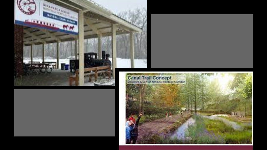
The National Canal Museum in Easton is dedicated to telling the story of America’s historic towpath canals.
In Easton, the Lehigh Canal connected with the Pennsylvania Canal’s Delaware Division and the Morris Canal.
Also known as the Delaware Canal, the Pennsylvania Canal was said to have built the Delaware Canal to feed anthracite coal to Philadelphia in the years between 1828 and 1834.
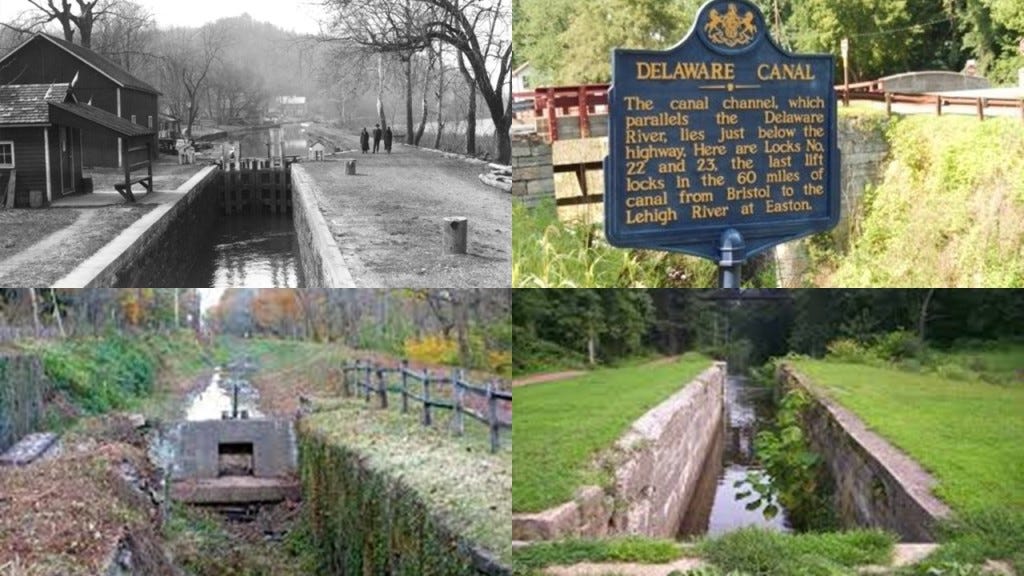
It ran along the right bank of the Delaware River for 60-miles, or 97-kilometers, to Bristol, just north of Philadelphia.

The Morris Canal was 107-miles, or 172-kilometers, -long and said to have been completed in 1832 to carry anthracite coal across northern New Jersey between where it connected to the Delaware Canal in Easton, to what is today Jersey City on the Hudson River.
It was closed in 1924.
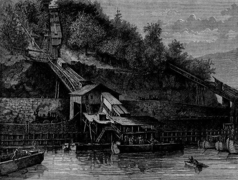
It was hailed as an ingenious, technological marvel for its use of water-driven, inclined planes.

The builders of the Morris Canal used a sophisticated power house technology, pictured here, to power the water turbine that was set in motion to raise or lower cradled boats on the inclined planes by means of a cable.
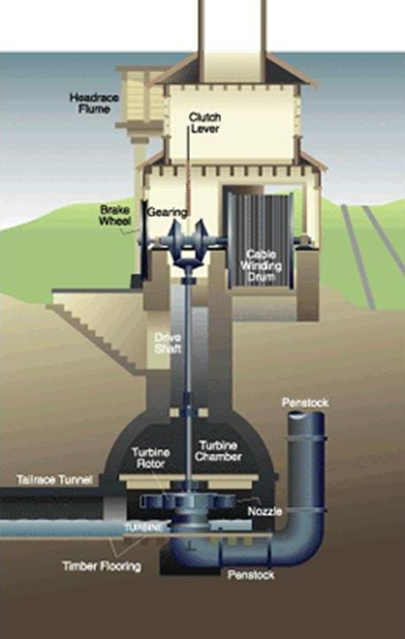
Yet they still needed mules to pull the canal boats in places on the Morris Canal in spite of all that sophisticated technology?
So in my opinion, the first of the original infrastructure we see coming back on-line in the post-cataclysmic “New World” were the canals.
In the “Old World,” the power supply for the canals would have been the same free-energy generated by the Earth’s worldwide grid system, and in the “New World,” they had to use mule-power to be able to utilize the original canal system because that was all they had available for power.
Back to the Lehigh Gorge State Park.
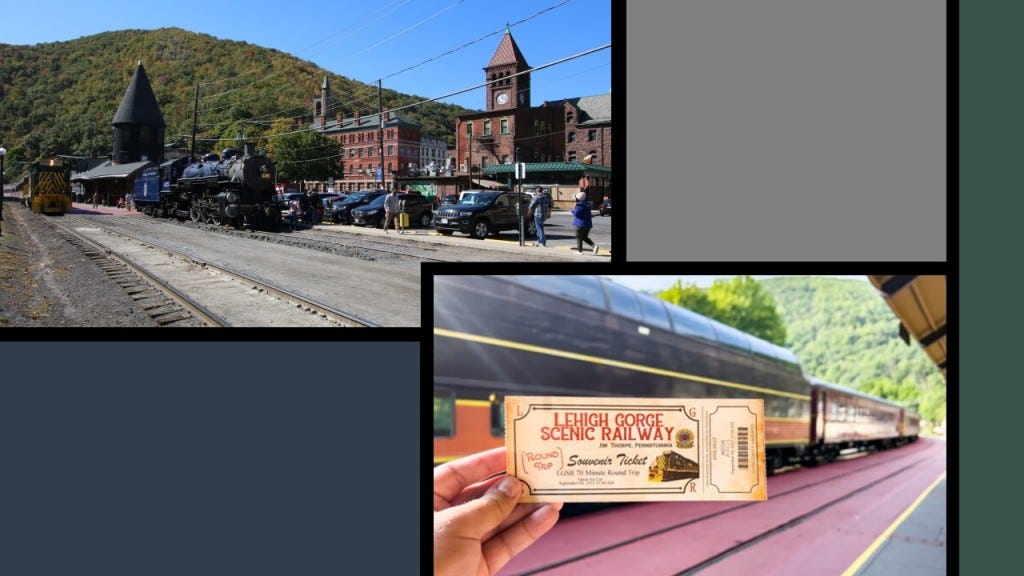
What remains of the original Lehigh Valley Railroad operations run today as the Lehigh Gorge Scenic Railway.
The excursion through the Lehigh Gorge begins in Jim Thorpe, Pennsylvania, formerly known as Mauch Chunk, at the southern end of the state park.
Mauch Chunk was nicknamed “The Switzerland of America” for its steep hillsides, narrow streets, and terraced gardens.
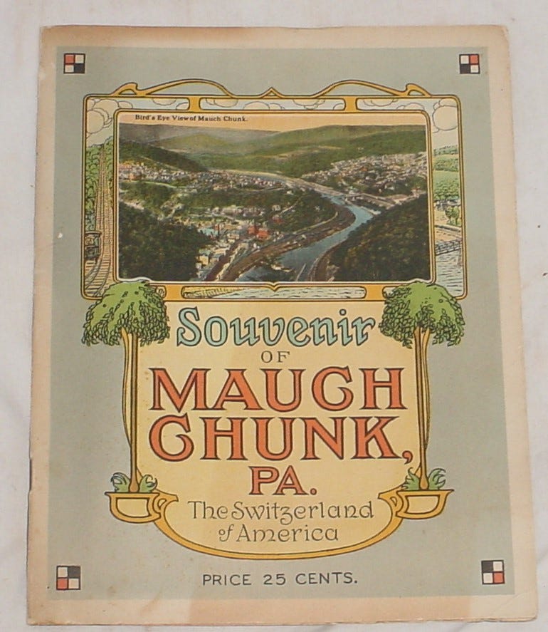
The Asa Packer Mansion here was said to have been completed in 1861, which would have been the first year of the American Civil War.
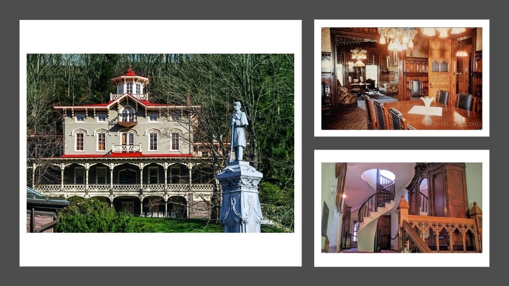
We are told that Asa Packer was, among other things, a coal and railroad magnate, philanthropist…
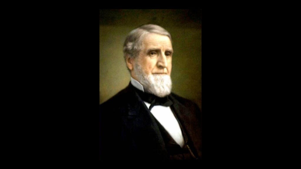
…and founder of Lehigh University in nearby Bethlehem, Pennsylvania, which was founded in 1865, the last year of the American Civil War.

At the time of his death, the value of Asa Packer’s estate was $54.5-million, and he was considered to be the richest man in the Commonwealth of Pennsylvania at that time.

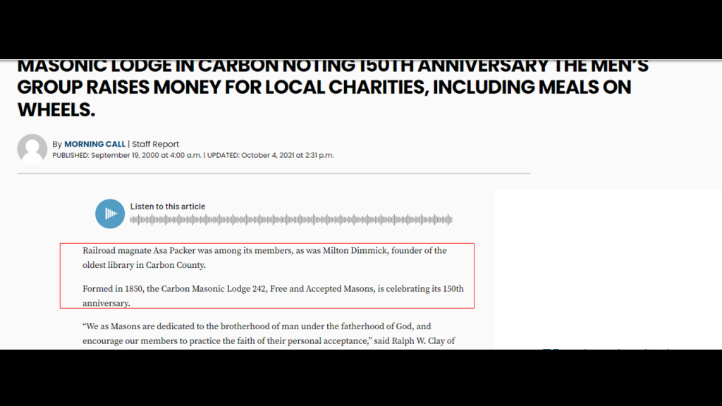
And Asa Packer was a Freemason too.
Renamed Jim Thorpe in 1954 for the Native American sports’ legend who was buried here, Mauch Chunk was founded as a company town in 1818 by Josiah White and his partners who were also founders of the Lehigh Coal and Navigation Company.
The Lehigh Coal and Navigation Company was a mining and transportation company that was headquartered in Mauch Chunk.
It operated from 1818 until it was dissolved in 1964 and was known for having an early and influential role in the American Industrial Revolution.
The Lehigh Coal and Navigation Company was considered to be the first vertically-integrated company in the United States.
Vertical integration is where the supply chain of a company is owned by the company.

Other examples of the adoption of the business practice of “vertical integration” off the top of my head was by Adolphus Busch as head of Anheuser-Busch Brewing Association.
Busch adopted vertical integration as a business practice, in which he bought all the components of his business, from bottling factories to ice-manufacturing plants to buying the rights from Rudolf Diesel to manufacture all diesel engines in America.
This illustration was of the Bevo Bottling Facility in St. Louis.
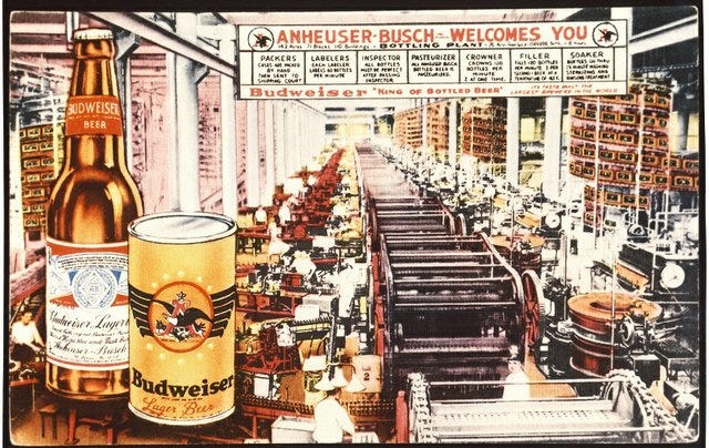
Adolphus Busch died in 1913, with a net worth $60 million at the time of his death.

Henry Ford also utilized the practice of “vertical integration” in the Ford Motor Company.
The introduction and refinement of the assembly line facilitated the mass production of new cars, which in turn made the purchase of a new car affordable for most people.
As we go through all the information that will be presented in this post, we will see why this was yet another replacement technology for the original transportation system, which was powered by free energy.
Henry Ford was also the 13th-wealthiest American of all-time according to CNN Business, with an adjusted wealth of $67.2-billion.

Henry Ford was also an acknowledged 33rd-degree Freemason.

Back to the Lehigh Coal and Navigation Company and Mauch Chunk.
It had its beginnings as the Lehigh Coal Mine Company in 1792, after, we are told, a hunter named Philip Ginter discovered anthracite coal on Pisgah Mountain near Summit Hill, near the border between Luzern and Carbon Counties.

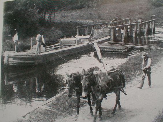
The Lehigh Coal Mine Company was incorporated in 1793 and acquired 10,000- acres, or 4,000-hectares, in and around the Panther Creek Valley and Pisgah Mountain, in order to bring anthracite coal from the large deposits on Pisgah Mountain to Philadelphia via mule-trains and coal arks, or one-time single use boats, on the Lehigh and Delaware Rivers.
We are told that while the original Lehigh Coal Mine Company was able to sell all the coal it could to the available market, it lost a lot of coal to the rough waters of the unimproved Lehigh River, so they sold the original company to Josiah White and his partners in 1818.
In a nutshell, this is what we are told.
In the same year, in 1818, the new owners of the Lehigh Coal Mine Company, began the construction of the Lehigh Canal, and that it became usable in 1820.
The Lehigh Canal enabled the transport of anthracite coal, a primary energy source at the time, to the primary markets in the northeastern United States, and, we are told, inspired the development and connection of other regional canals.
The new owners of the Lehigh Coal Mine Company were said to have been behind of the construction of the Lehigh and Susquehanna Railroad between 1839 and 1841…

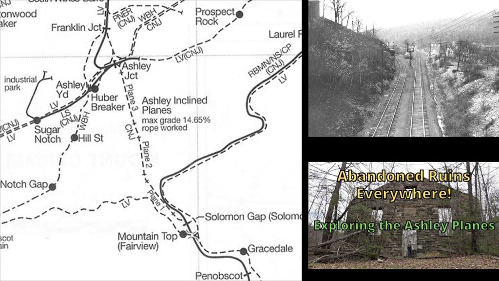
…the Ashley Planes, an historic freight-cable railroad between Ashley and Mountain Top said to have been built between 1837 and 1838 to transport millions of tons of anthracite coal over the Wilkes-Barre Mountain…
…. and brought in blast furnace technology to the Lehigh Valley, a type of metallurgical furnace used for smelting to produce industrial metals.
Smelting is defined as a process by which metal is obtained, either as a single element or compound.

In 1822, the company became the Lehigh Coal and Navigation Company, after which time we are told they built the Mauch Chunk and Summit Hill Railroad.
The Mauch Chunk and Summit Hill Railroad, also known as the Mauch Chunk Switchback Railway, was said to have been built in 1827 and operated until 1932.
It was said to be the second permanent railway constructed in the United States, and used to transport coal down Summit Hill to the Lehigh Canal.
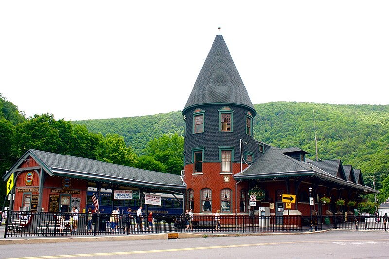
Mauch Chunk/Jim Thorpe was also a key location on the Central Railroad of New Jersey in the shipping of anthracite coal.
The Central Railroad of New Jersey was said to have built the Mauch Chunk Station in 1888 in the Queen Anne Victorian Architectural-style.
Today it is owned and operated by the Lehigh Gorge Scenic Railroad.
This is what we are told about the Central Railroad of New Jersey.
The origins of the Central Railroad of New Jersey began in 1831 with the incorporation of the Elizabeth and Somerville Railroad, and which was operational by 1842.
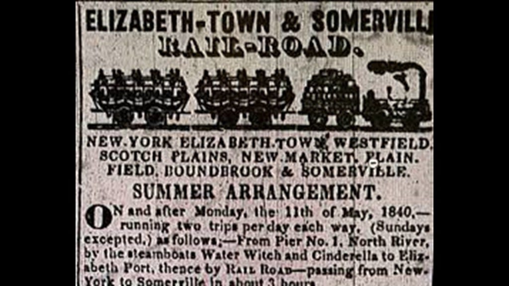
In 1847, the Somerville and Easton Railroad was incorporated, purchased the Elizabeth and Somerville, and the name was changed to the Central Railroad Company of New Jersey.
By 1852, the line reached Phillipsburg, New Jersey, on the Delaware River and was extended across Newark Bay to Jersey City in 1864 (one-year before the end of the American Civil War in 1865).
From Jersey City, the railroad kept extending out to major cities like Newark, Flemington, Perth Amboy, Chester and Wharton.
We are told that the Lehigh Coal and Navigation Company built the CNJ’s lines in Pennsylvania, which was used primarily for the shipment of anthracite coal.
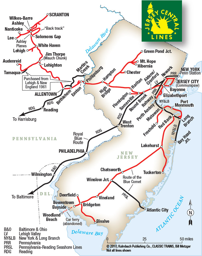
The Central Railroad of New Jersey Terminal in Jersey City was said to have been built in 1889 to replace an earlier one, and is located next to the Big Basin of the Morris Canal on the Hudson Waterfront in today’s Liberty State Park, as it is in close proximity to Ellis Island and the Statue of Liberty in Upper New York Bay.
It was operational as a terminal until April 30th of 1967.
An estimated 10.5 million immigrants processed through here at one time in America’s history when Ellis Island was operational as an immigrant processing station between 1892 and 1954.

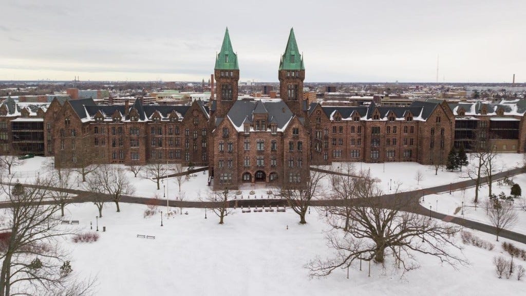
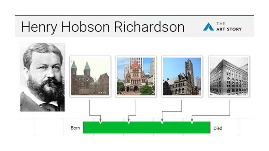
The architectural style of the Central Railroad of New Jersey Terminal building is called Richardsonian Romanesque, after architect Henry Hobson Richardson, who was said to have first used elements of this style in the Buffalo State Asylum for the Insane in Buffalo, New York, which he is said to have designed in 1870, and Frederick Law Olmsted was the landscape architect, and the Kirkbride Plan was implemented here.
The Buffalo State Asylum for the Insane was closed for that purpose in the 1970s.
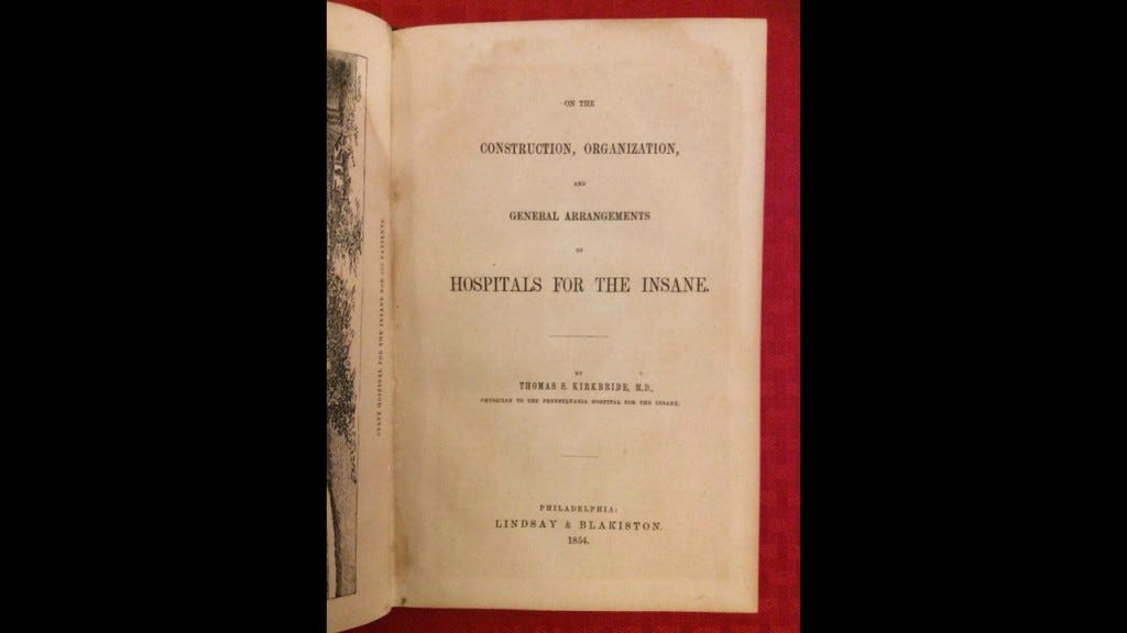
In 1854, Dr. Thomas S. Kirkbride first published what was considered the source book in the 19th-century for Psychiatric Directives entitled “On the Construction, Organization, and General Arrangements of Hospitals for the Insane, ” with some remarks on insanity and its treatment.
We are told that throughout the 19th-century, numerous insane asylums were designed and constructed according to the Kirkbride Plan across the U. S. and while numerous Kirkbride structures still exist, many have been demolished, partially-demolished, or repurposed.

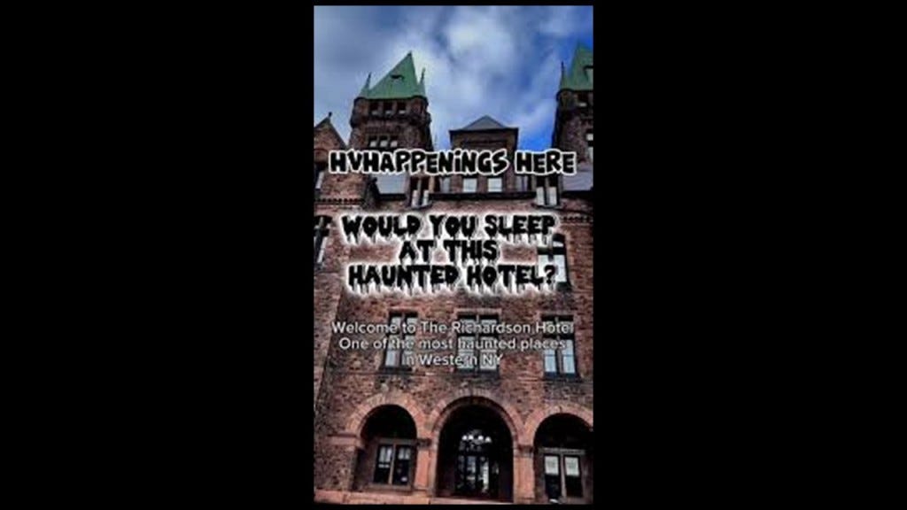
Today the former Buffalo State Asylum for the Insane is known as the Richardson Olmsted Complex, and was repurposed as a hotel which opened in 2023…
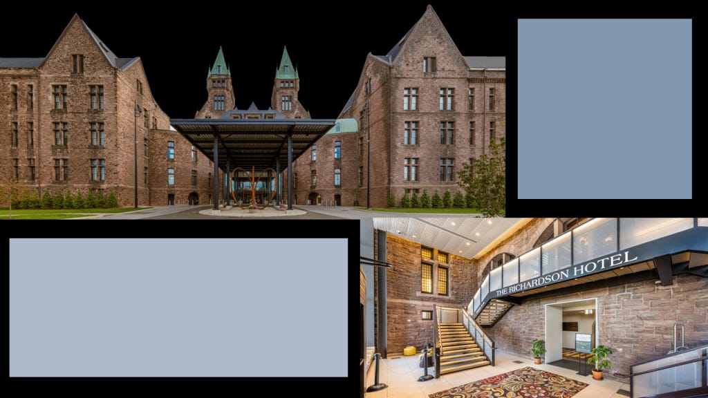
…and is considered one of the most haunted places in Buffalo, if not western New York.
Richardsonian Romanesque is described as a free revival style, incorporating 11th and 12th century southern French, Spanish, Italian Romanesque characteristics.
Henry Hobson Richardson had a relatively short career,and didn’t even complete his architecture school training in Paris because he lost family backing because of the American Civil War, yet somehow by the time he died at a relatively young age of 47 in our historical narrative, he left behind a legacy of mind-blowingly ornate architecture!
One more thing about the Central Railroad of New Jersey here.
All of the new railroad lines that were popping up betwixt and between these large population centers and the Jersey Shore were, like Atlantic City, were going right through the desolate, swampy and forbidding Pine Barrens.

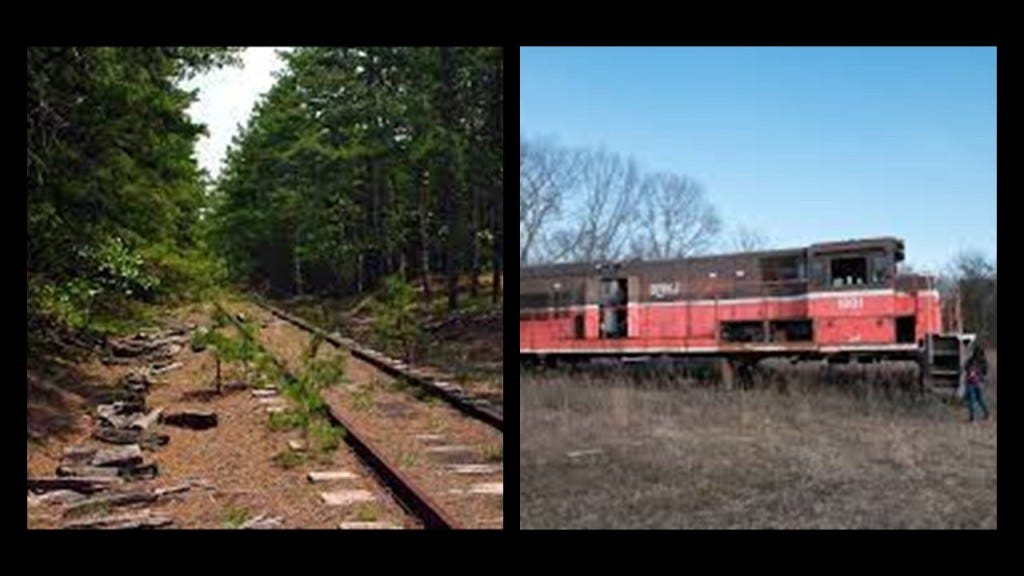
Today there are abandoned trains and railroad lines found throughout the New Jersey Pine Barrens.
The Delaware, Lackawanna and Western Railroad main line passed through the southern end of the Mount Pocono Borough, which provided access to the borough from New York City via the terminal at Hoboken, New Jersey.
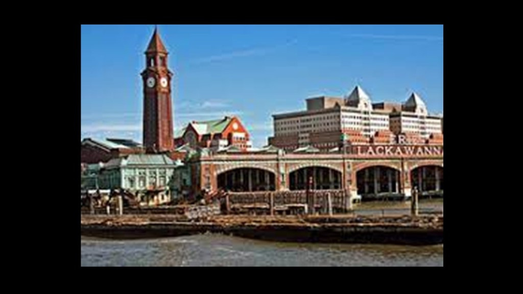
One of the New York area’s major transportation hubs, the terminal at Hoboken was said to have been constructed by the Delaware, Lackawanna and Western Railroad in 1907, and combined railroad, ferry, subway, streetcar and pedestrian services.
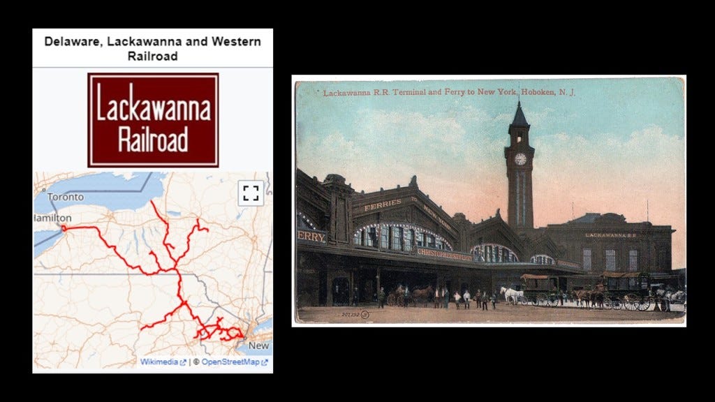
We are told that numerous electric streetcar lines originated and ended at the station until the completion of “Bustitution” in August of 1949, at which time they were replaced by buses.
This included the Hoboken Inclined Railway…
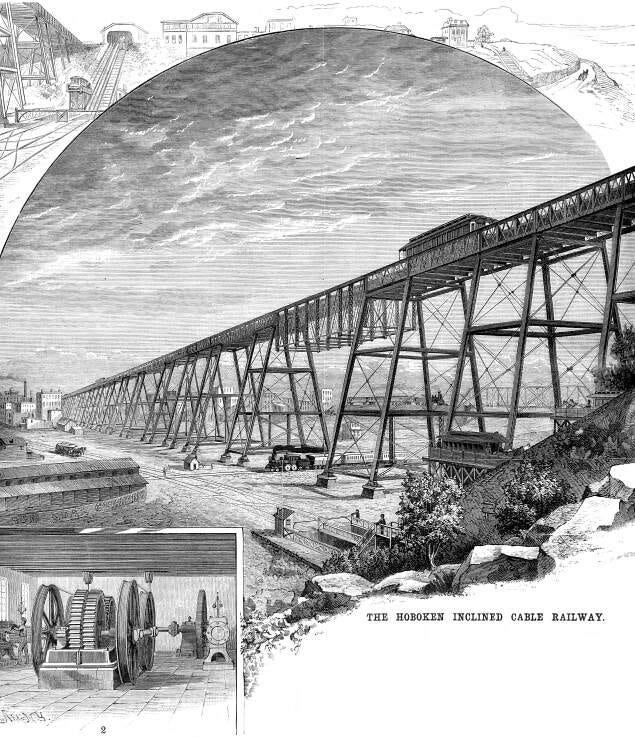
…which consisted of several lines including the Palisade Line that travelled from Edgewater to Palisades Amusement Park, which operated from 1898 to 1971…

…and the Eldorado Elevator, which met a streetcar line that travelled along a trestle to a cut in the Palisades which ran parallel to the Eldorado, an amusement park that opened in 1891 and closed as an amusement park in 1894, except for the hotel casino, which was described as “Moorish Inspired.”

The Eldorado’s main building was used to host boxing matches and Vaudeville performances until it burned down in a massive fire in 1898.

There is still a Hoboken Terminal in use today as an intermodal transportation hub.
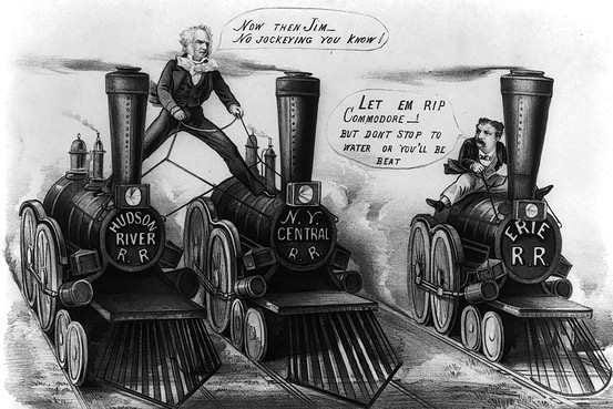
The New York Central Railroad was said to have begun operating in 1853 with the consolidation of earlier independent companies running between Albany and Buffalo.
This graphic depicts the New York Central rail system as of 1918.

Staten Island-born Cornelius Vanderbilt got his start in regional steamboat lines and ocean-going steamships, and from there got into the railroad business.
He bought control of the Hudson River Railroad in 1864; the New York Central Railroad in 1867; the Lake Shore and Michigan Southern Railroad in 1869; and the Canada Southern Railway in 1876.
He consolidated his two key lines into the New York Central and Hudson River Railroad in 1870, becoming one of the first giant corporations in the history of the United States
According to CNN Business, Cornelius Vanderbilt was the second-richest American in history, with an adjusted wealth of $205-billion.


I was also able to find a reference saying that the Vanderbilts were known Freemasons.

I have taken a very close look at the region of Pennsylvania around the Moshannon State Forest in Philipsburg Borough and its official history, which among other things, was important to the settlement and industrialization of America, and also the wealthy and influential men behind it all.
We are told Philipsburg Borough was founded in 1797 by one Henry Phillips, who purchased 350,000 acres on the western side of the Allegheny Mountains for $173,000, and then proceeded to auction the land off on the streets of Philadelphia for two-cents per acre.

The region developed around the coal-mining and lumber industries.
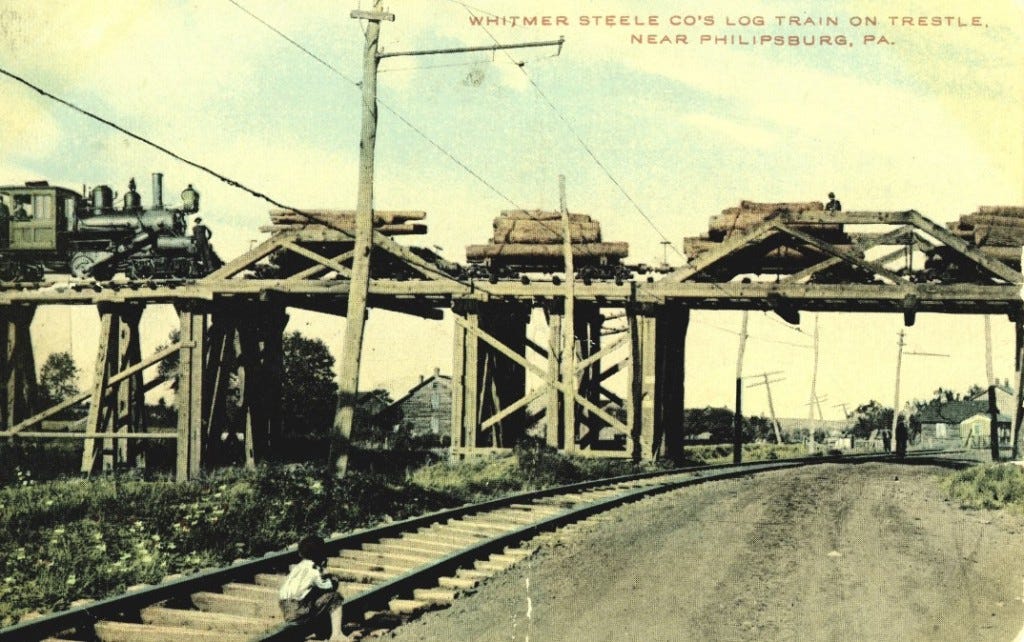
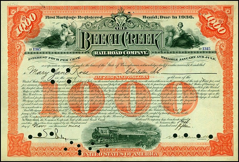
The Beech Creek Railroad between the South Jersey Shore and Mahaffey Borough, Pennsylvania, and part of the Susquehanna and South Western Railroad, was used for coal mining services in the region starting in 1884.
This railroad ran near State College, home of Penn State University, and not far from Altoona, Pennsylvania.
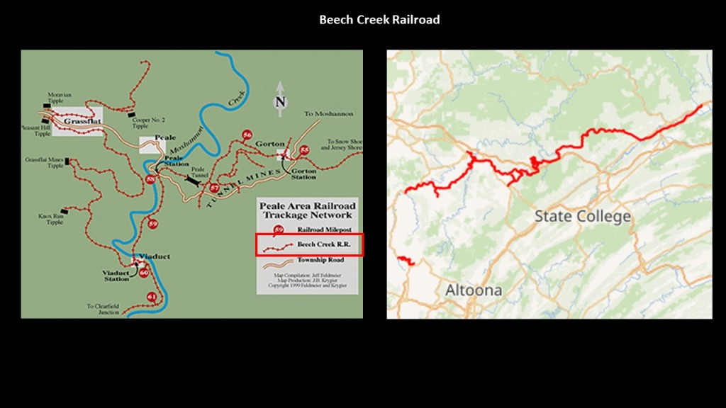
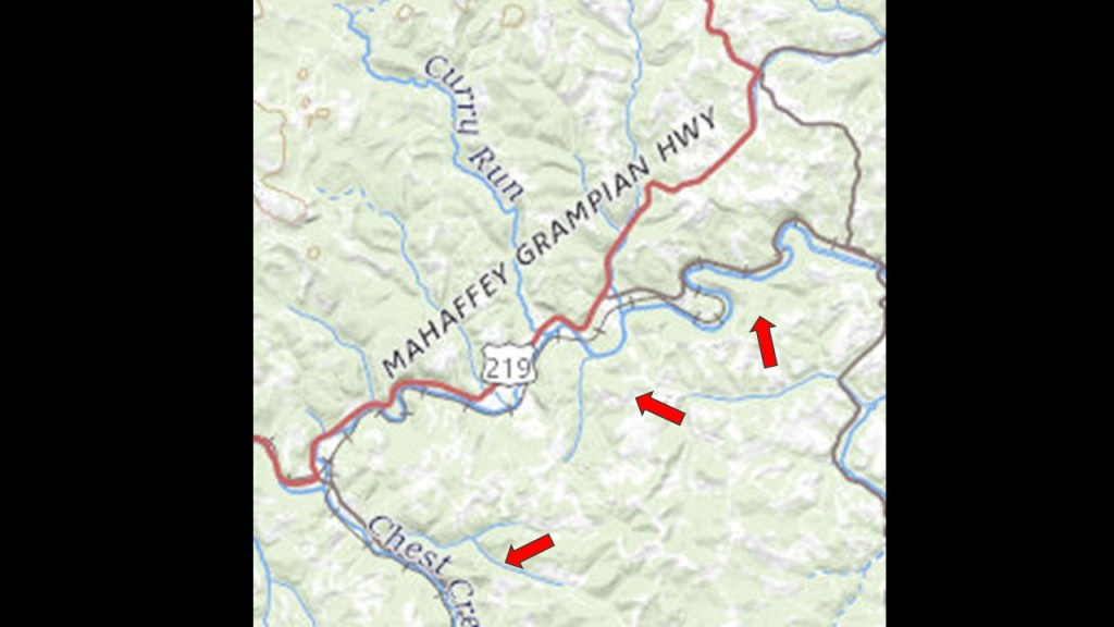
Mahaffey Borough, first incorporated in 1841, was located on U. S. Route 219, at the junction of the New York Central Railroad and the Hudson River Railroad.
The arrows point to where railroad tracks ran along s-shaped river-bends. on this section of Route 219 going through Mahaffey Borough.
This railroad project in Pennsylvania was said to have been backed and financed by William H. Vanderbilt, the oldest son of Cornelius Vanderbilt, and who was President of the New York Central Railroad.
William H. Vanderbilt had developed a plan to facilitate railroad access to enter the “Clearfield Coalfield,” a large, juicy coal-mining area in Clearfield County, which would have been otherwise exclusively accessed by the Pennsylvania Railroad.
It was said to have been constructed starting at the end of 1882 to high-standards, including extensive curvature, bridges, and a tunnel, and became operational in November of 1884.
Eventually, this railroad line provided passenger service and used as such until 1990.
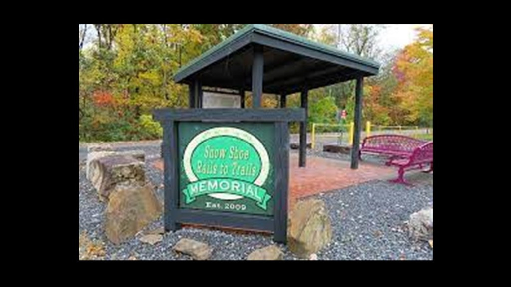
In 1994, the right-of-way was acquired by the Headwaters Charitable Trust for the “Snowshoe Rail-to-Trail Project” and the rail went away.
Along with the coal-mining going on in Pennsylvania, there were extensive logging activities.
For example, the Moshannon State Forest near Phillipsburg was formed as a direct result of the depletion of the forests of Pennsylvania that happened in the mid-to-late 19th-century, when lumber and iron companies clear-cut the forests.
Then we are told that sparks from passing steam-locomotives caused wildfires from the remnants of the forest-lands, preventing the growth of new forests.
The land that became Moshannon State Forest was purchased by the State in 1898.
The old-growth forest was gone by 1921, with a second-growth forest replacing it since then.
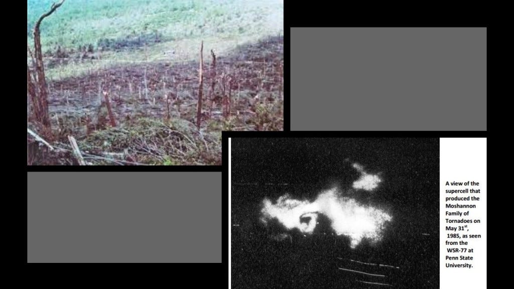
Interesting to note that a tornado in 1985 tore through the forest and destroyed an estimated 88,000 trees.
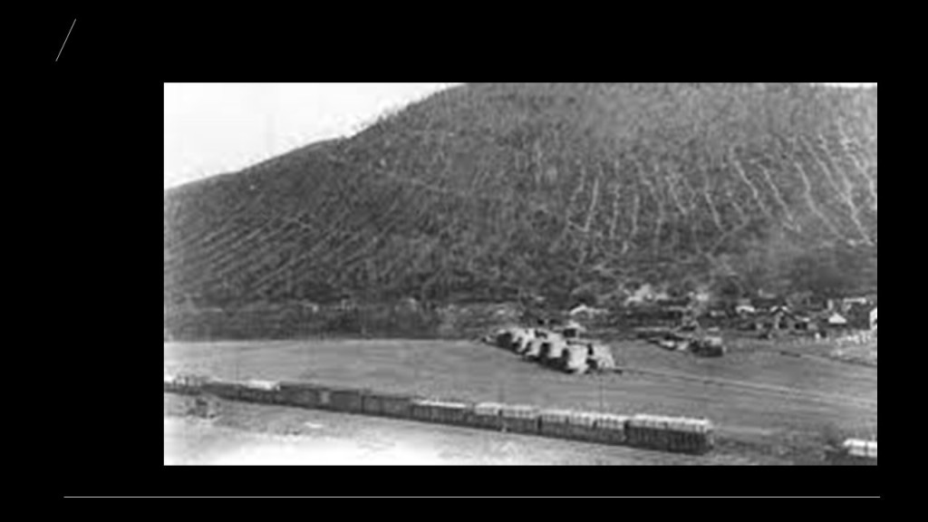
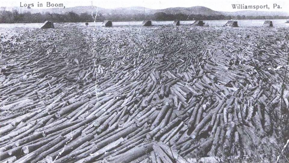
There was much logging going on from this region, so the “Susquehanna Boom” was said to have been built in the 1850s across the West Susquehanna River at Williamsport, a system of cribs and chained logs designed to catch and hold floating timber until it could be processed, and logging railroads built to transport the lumber, to the tune of 45-cars per day until logging ended here when all the trees were gone.
The lumbermen left a barren landscape that was devastated by fires, flooding and erosion formany years, until the CCC came in the 1930s and started replanting trees after the State of Pennsylvania bought the deforested land from the Central Pennsylvania Lumber Company in 1930.

The Civilian Conservation Corps CCC operated from 1933 to 1942 in the U.S. for unemployed, unmarried men to do manual labor related to the conservation and development of natural resources in rural lands owned by federal, state, and local governments.
Originally for young men ages 18–25, it was eventually expanded to ages 17–28.
In the nine-years of its operation, the CCC employed 3,000,000 young men, providing them with food, shelter and clothing, and a wage of $30/month, $25 of which had to be sent home to their families.
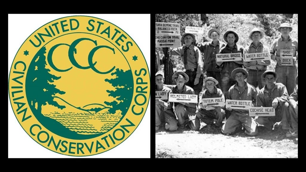
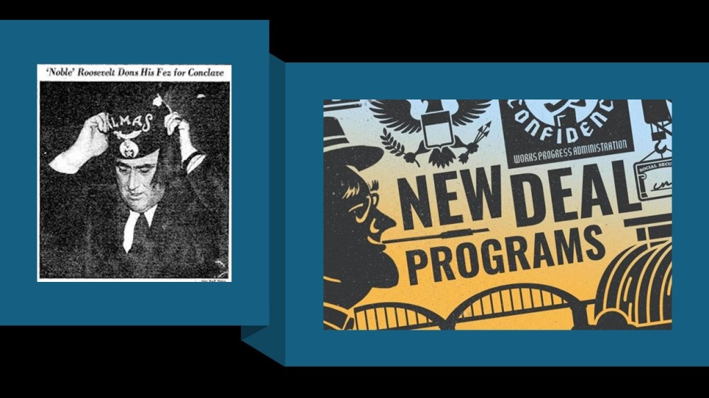
There is no doubt in my mind that the CCC, and the other alphabet programs of FDR’s New Deal during the Great Depression, like the WPA and TVA, were being used to cover-up the ancient advanced civilization.
In the nearby city of State College, the location of the University of Pennsylvania, Andrew Carnegie had begun mining iron ore in Scotia in 1881 for his steel mills in Pittsburgh, and by 1887, we are told that a new era of iron-making in the Nittany Valley began, with the opening of the Nittany and Bellefonte Furnaces along Buffalo Run near its junction with Spring Creek, and three railroads that were said to have been constructed to haul the iron ore to them – the Bellefonte Central (BFC), Central Railroad (CRR) and Nittany Valley Railroad (NV).
By 1911 both of these furnaces had been shut-down.
By 1950, all the railroads that had once served the area, either for the iron-related industry or passenger service, including the Pennsylvania Railroad lines, circled in blue, were no longer in service.

The only historic rail here that became operational again was a portion of the Bellefonte Central after the Bellefonte Historical Railroad was organized as an excursion line in 1985, and occasionally offers runs as a tourist attraction.
Altoona in Pennsylvania is only 43-miles, or 70-kilometers southwest of State College.
Altoona was said to have been established by the Pennsylvania Railroad in 1849.

The “Horseshoe Curve” in Altoona is a three-track railroad curve that is described as one of the world’s most incredible engineering feats, and was said to be accomplished by the Pennsylvania Railroad in 1854.
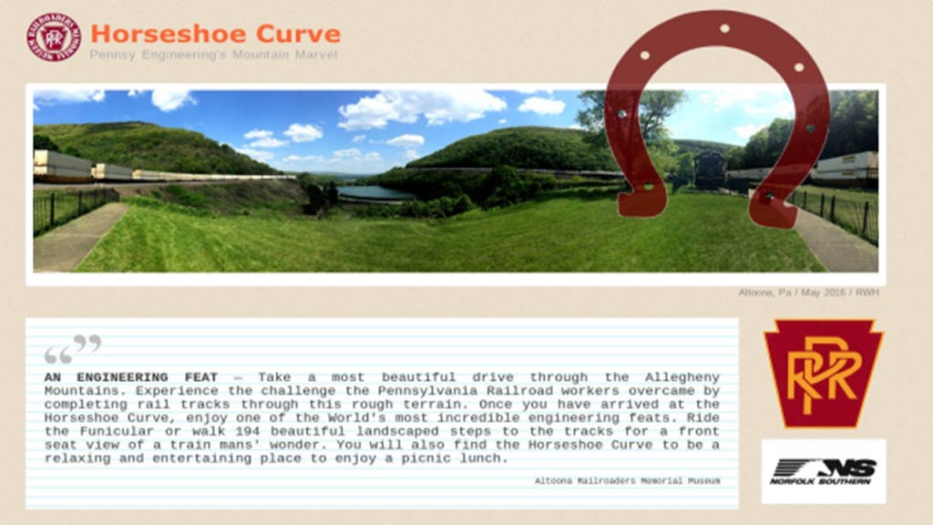
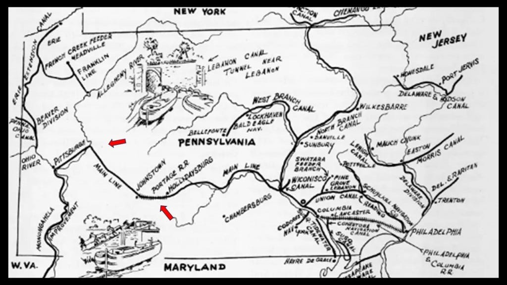
It was said to have replaced the original Allegheny Portage Railroad, which was said to be the first railroad constructed through the Allegheny Mountains in 1834, and connected to the Pennsylvania Canal, all of which was said to have been built as part of the transportation system by the “Main Line of Public Works” that was mentioned at the beginning of this post after it was passed by the Pennsylvania Legislature in 1826.
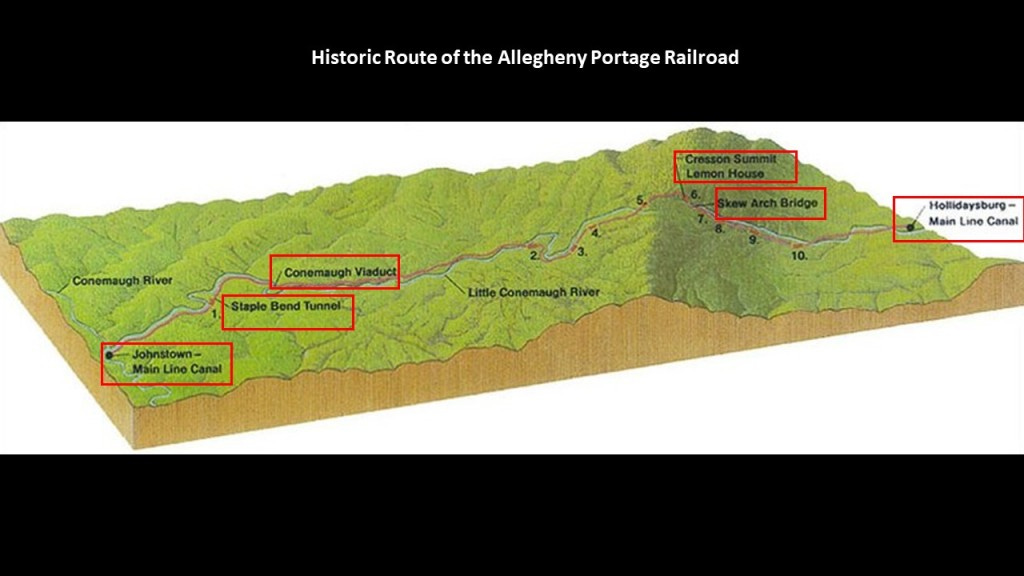
Considered a technological marvel in its day and critical to opening the way for commerce and settlement past the Appalachian Mountains, the original Allegheny Portage Railroad consisted of a series of five inclines on either side of the ridge-line to Cresson Summit alongside what is called the Little Conemaugh River to where it meets the Conemaugh River at Johnstown.
Interesting things to note along the historic route of the Allegheny Portage Railroad are as follows:
After leaving the main canal location of Hollidaysburg and going up towards Cresson Summit, we first come to the lopsided-looking “Skew Arch Bridge,” called the “only purposefully built bridge on the Portage” and crossed over the railway.
It was said to have been built in the 1830s as part of the early road system.
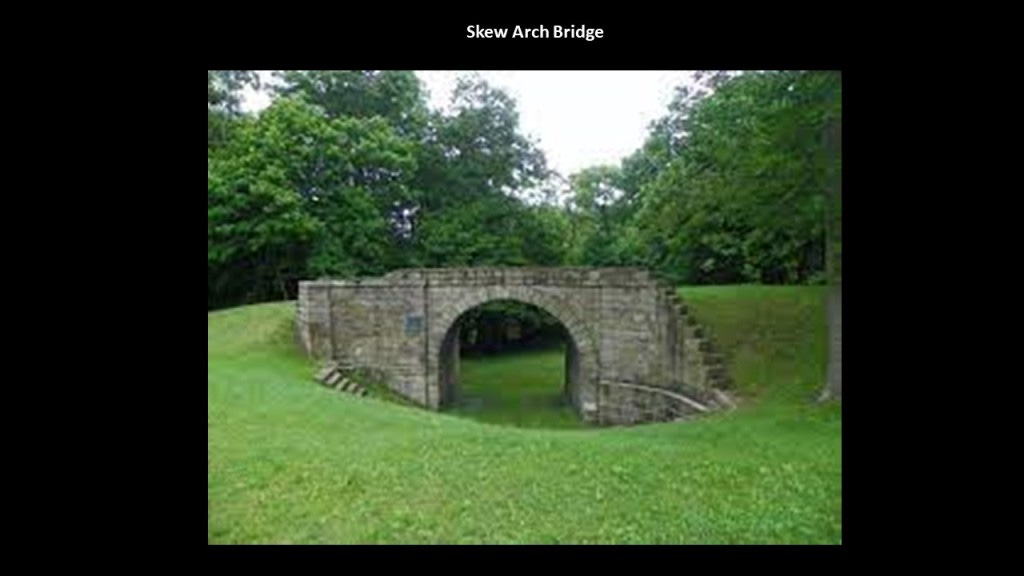
Today, the “Skew Arch Bridge” is preserved in the middle of “Old U. S. Route 22” and the new “U. S. Route 22.”
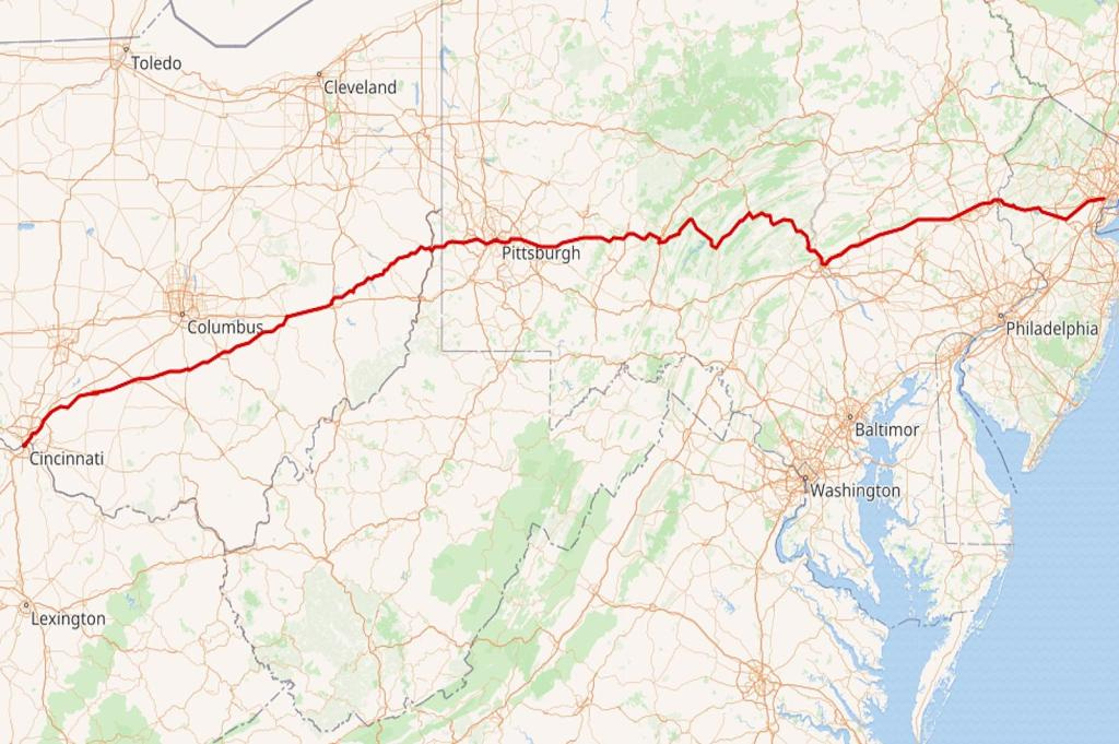
U. S. Route 22 is an East-West Numbered Highway from 1926 that runs from Cincinnati in Ohio to Newark in New Jersey, and passes through West Virginia and Pennsylvania on the way.
The next landmark on the Allegheny Portage Railroad’s journey through the Allegheny Mountains is the summit at Cresson, a borough (which in Pennsylvania is a municipal entity like a town or small city) on top of the Eastern Continental Divide.
US Route 22 is one of the highways that accesses Cresson.

Back in the industrial heyday of the late 19th-century and early 20th-century, there were lumber, coal and coke-yard industries located here.
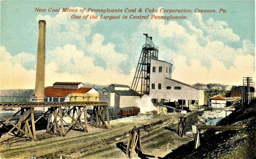
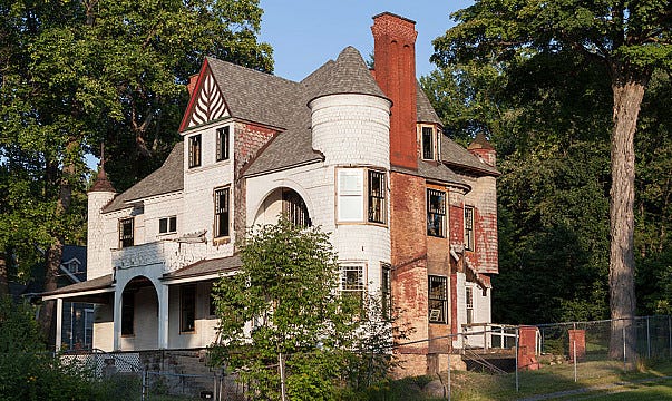
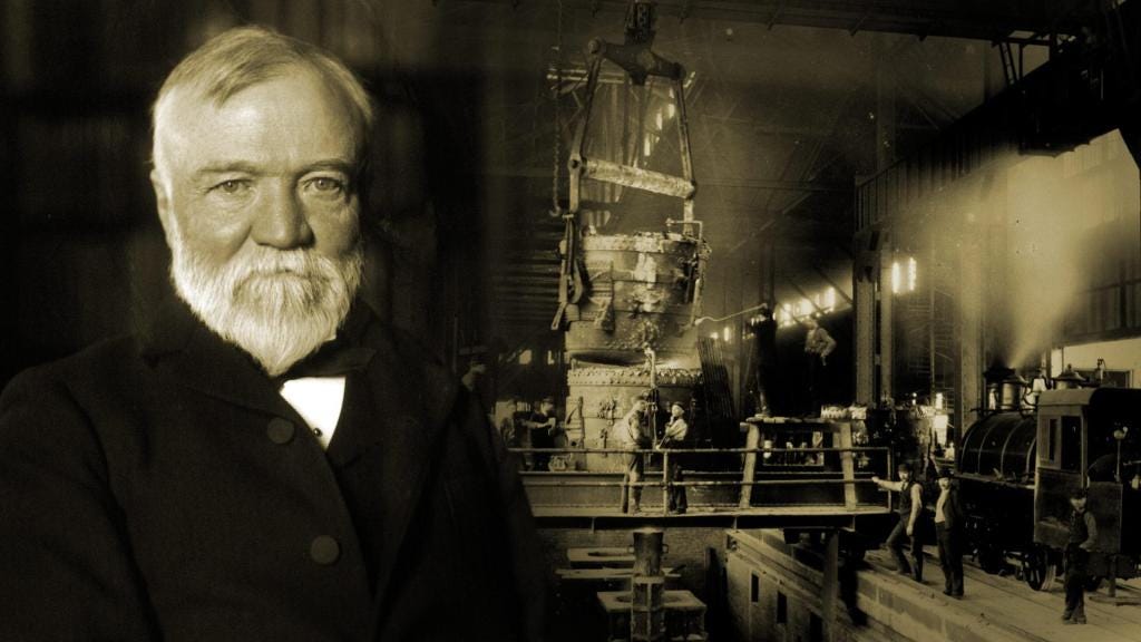
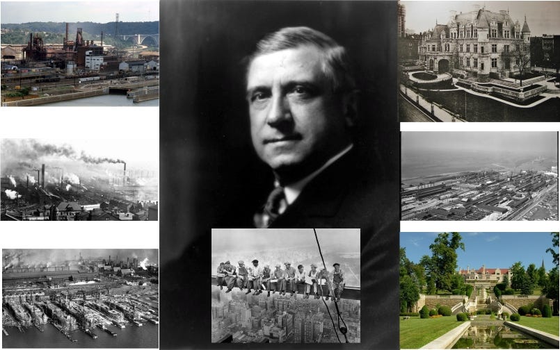
Wealthy Pittsburgh businessmen like Andrew Carnegie, Henry Clay Frick and Charles Schwab, all connected to each other through the steel industry, had summer residences here, like Carnegie’s Braemar Cottage in Cresson.
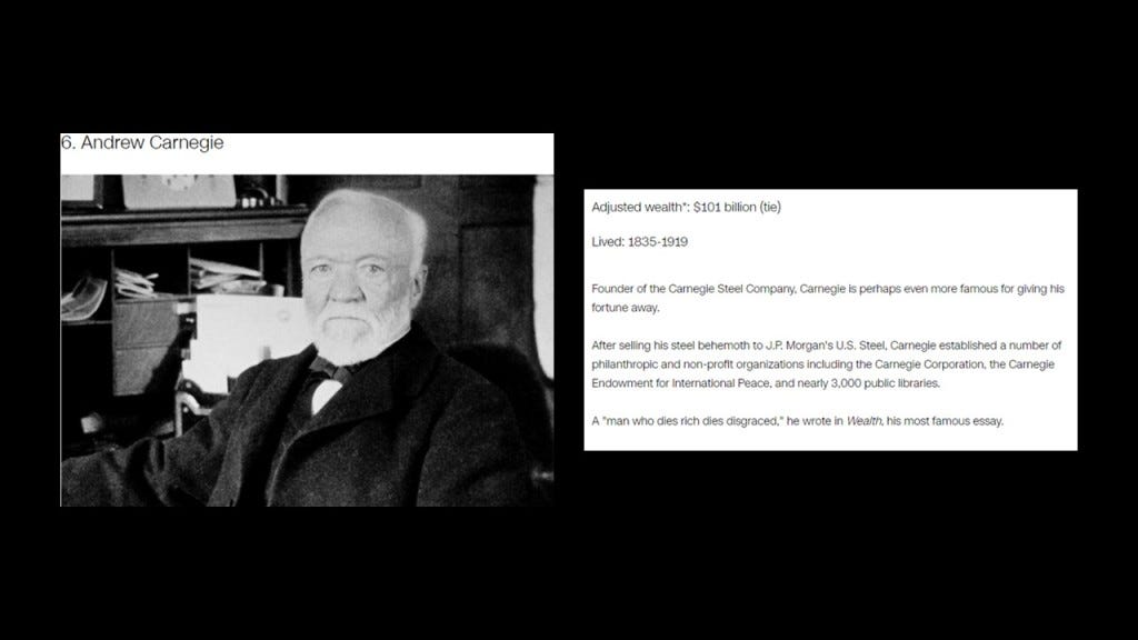
Andrew Carnegie was a Scottish immigrant to America, who came to Pittsburgh in 1848 with his parents at the age of 12, got his start as a telegrapher, and who by the 1860s, had investments in such things as railroads, bridges and oil derricks, and ultimately worked his way into being a major player in Pittsburgh’s steel industry.
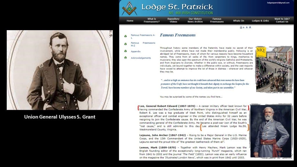
I couldn’t find a picture of Andrew Carnegie as a freemason, but I could find a reference to him being a “famous freemason” on a masonic website.

His first steel mill was operational by 1874, the Edgar Thomson Steel Works, named after the President of the Pennsylvania Railroad, with his partners, one of whom was Henry Clay Frick, the owner of a coke manufacturing company, a product used in making steel.
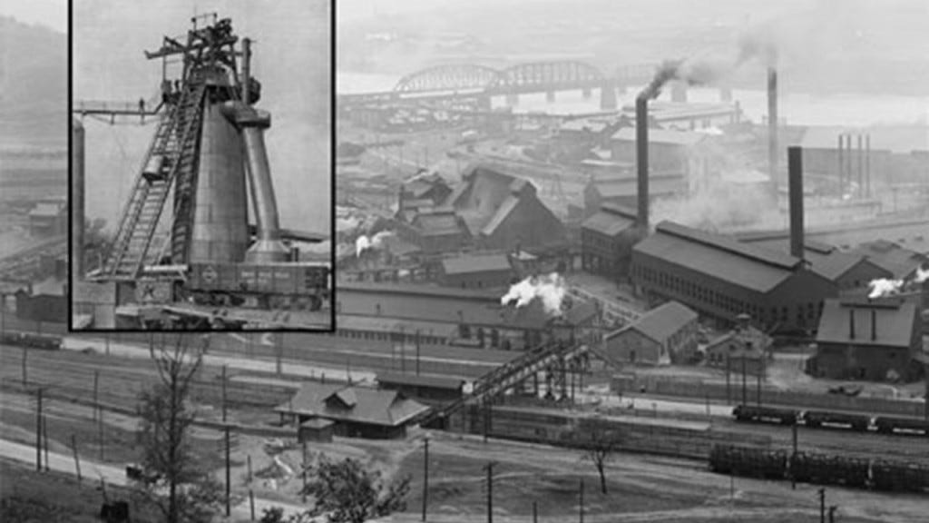
They subsequently acquired other steel mills, and in 1892, the Carnegie Steel Company was formed, of which Henry Clay Frick became chairman. and in 1897, Charles M. Schwab, who had gotten his start as an engineer at the Edgar Thomson Steel Works, became President of the Carnegie Steel Company in 1897.
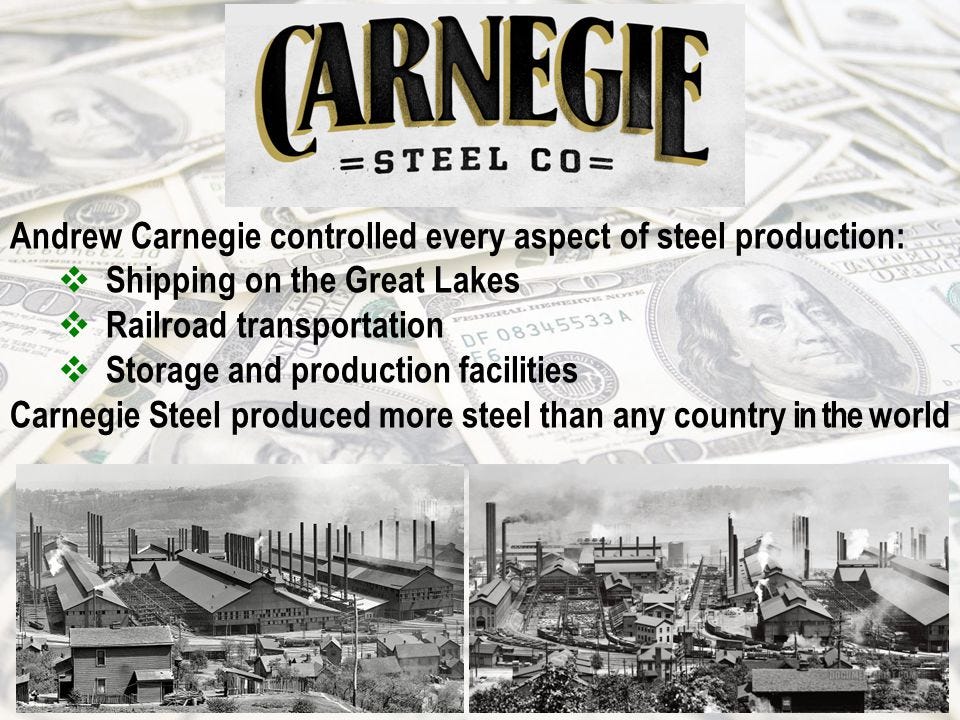
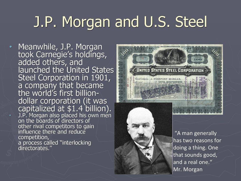
In 1901, Charles M. Schwab helped negotiate the sale of Carnegie Steel with a merger involving it with Elbert Gary’s Federal Steel Company, and William Henry Moore’s National Steel Company to a group of New York City Financiers led by J. P. Morgan.
After the sale of Carnegie Steel, Andrew Carnegie surpassed John D. Rockefeller as the richest American at the time, and Charles M. Schwab became the first President of the newly minted U. S. Steel Company.
Andrew Carnegie was ranked as the 6th-richest American of all-time by CNN Business, with an adjusted wealth of $101-billion.
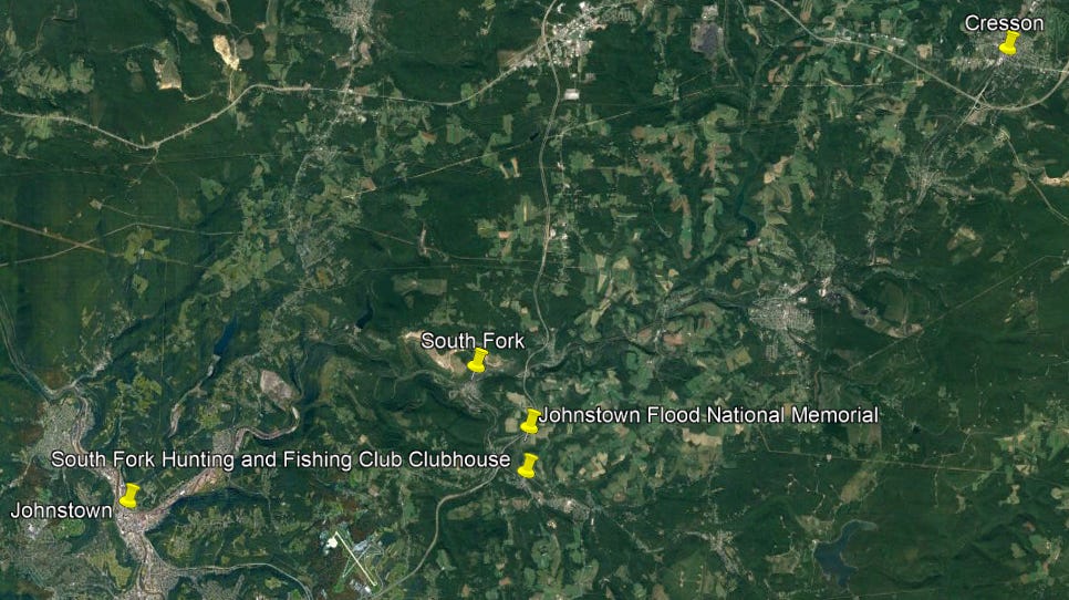
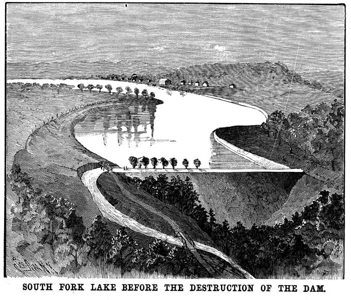
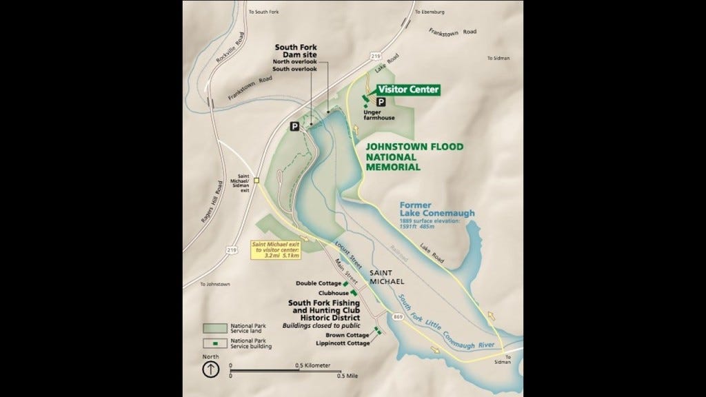
After the former Allegheny Portage Railroad left the summit at Cresson, on its downward descent in elevation into Johnstown, along the Little Conemaugh River, we come to the South Fork of the Little Conemaugh River and what was the former location of the South Fork Dam.
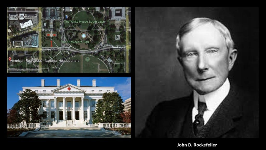
The famous Johnstown Flood on May 31st of 1889, the worst flood in the United States in the 19th-century, was caused by the catastrophic failure of the South Fork Dam, and was the second major disaster the American Red Cross responded to, after the Michigan Thumb Fire, which started on September 5th of 1881, with hurricane-force winds and hot and dry conditions this was less than four months after the establishment of the American Red Cross in May of 1881.
John D. Rockefeller was amongst several that donated to create a national headquarters for the American Red Cross near the White House in Washington, DC, said to have been built between 1915 and 1917.
More on John D. Rockefeller shortly.
The South Fork Dam was said to have been an earthwork built between 1838 and 1853 as part of a canal system as a reservoir for a canal basin in Johnstown by the Commonwealth of Pennsylvania.
But then, after spending 15-years building the dam, it was abandoned by the Commonwealth, and sold to the Pennsylvania Railroad, who turned around and sold it to private interests.
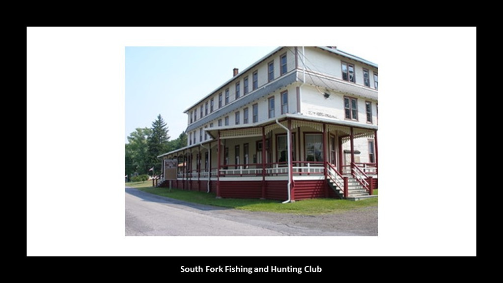
In 1881, speculators had bought the abandoned reservoir and built a clubhouse called the South Fork Fishing and Hunting Club and cottages, turning it into an exclusive retreat for 61 steel and coal financiers from Pittsburgh, including Andrew Carnegie, Henry Clay Frick, Andrew Mellon, Philander Knox, John Leishman, and Daniel Johnson Morrell.
The South Fork Fishing and Hunting Club was a Pennsylvania Corporation and owned the South Fork Dam.
Henry Clay Frick was a founding member of the South Fork Fishing and Hunting Club, and was actually said to have been largely responsible for the alterations to the South Fork Dam that led to its failure.
Interesting to note that I did find this reference on the website of the Pleasant Valley Masonic Center in Connellsville, Pennsylvania, that Henry Clay Frick was a freemason in its King Solomon’s Lodge #346 from 1872 to 1877 , at which time he resigned as an active mason, but from what this entry says, his masonic lodge continued to enjoy the benefits of his generosity long afterwards, as well as that of his daughter.

What we are told is that the South Fork Dam failed after days of unusually heavy rain, and 14.3-million-tons of water from the reservoir of Lake Conemaugh devastated the South Fork Valley, including Johnstown 12-miles, or 19-kilometers, downstream from the dam, killing an estimated 2,209 people and causing $17-million in damages in 1889, which would be $490-million in 2020.
Though there were years of claims and litigation, the elite and wealthy members of the South Fork Fishing and Hunting Club were never found liable for damages.
In 1904, the South Fork Fishing and Hunting Club corporation was disbanded and assets sold at a public auction by the sheriff, and there were permanent exhibits in many places, like Atlantic City, depicting the horrors of the Johnstown Flood experience for public consumption, billed as a “Thrilling Account of the awful floods and their appalling ruin.”
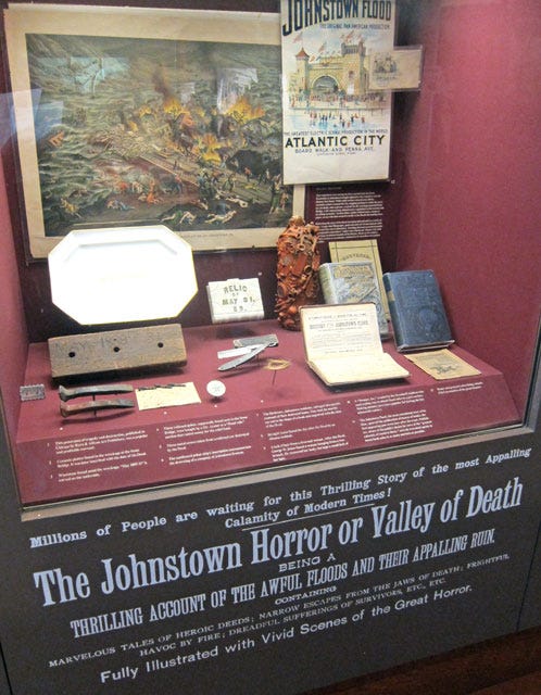
The South Fork Fishing and Hunting Club building and the nine-remaining of sixteen club member cottages still stand today, and are under the auspices of the National Park Service as part of the Johnstown Flood National Memorial.
So now we come to Johnstown, which is located 57-miles, or 92-kilometers, east of Pittsburgh.
It is at the confluence of the Conemaugh and the Stonycreek Rivers.
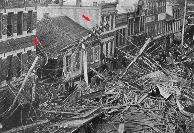
The is a map of the 1889 Johnstown Flood direction from the National Park Service map.
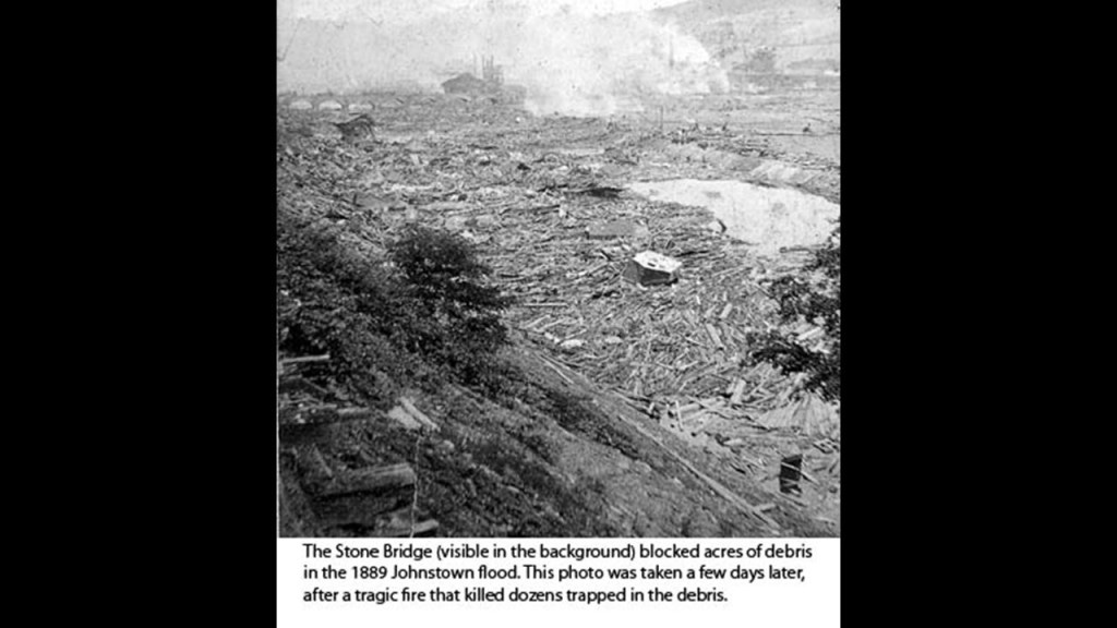
“Mass of debris” is marked at the Stone Bridge location.
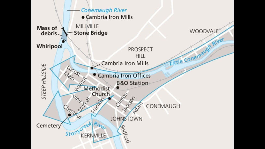
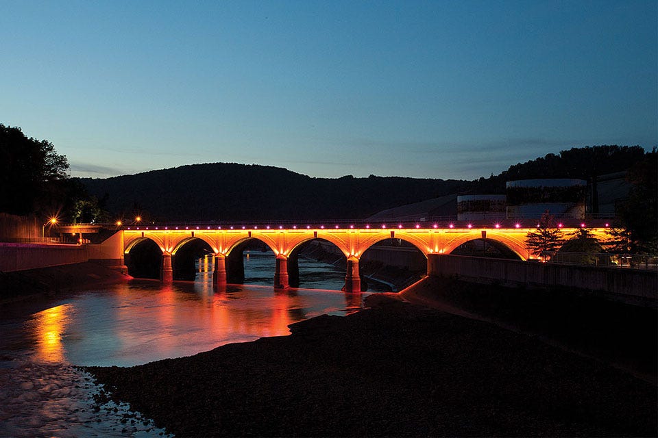
The Stone Bridge is a 7-arch railroad bridge that was said to have been constructed by the Pennsylvania Railroad between 1887 and 1888.
The Stone Bridge itself survived the flood, but it trapped all kinds of debris, including miles of barbed wire, that had been swept away by the raging floodwaters.
The debris at the bridge caught on fire and burned for three days, killing many people that were trapped in the debris.
If the failure of the South Fork Dam, and the subsequent catastrophic Johnstown Flood was deliberately caused by prestigious members of the South Fork Fishing and Hunting Club, which evidence in the narrative suggests was the case, then apparently these men had had no care or concern for the death, destruction and suffering for which they were never held accountable that they caused downriver.
From 1834 to 1854, Johnstown was a key transfer point on the Pennsylvania Main Line Canal.
At the head of the canal’s western branch, canal boats were transported over the mountains by the Allegheny Portage Railroad to continue the trip by water to Pittsburgh at the “Forks of the Ohio” and on to the Ohio River Valley.
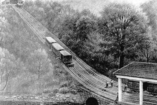
Both Johnstown on the one side of the Allegheny Portage Railroad and the Horseshoe Curve near Altoona on the other side, might have operational remnants of the original incline railway system, though that’s not what we are told about them.
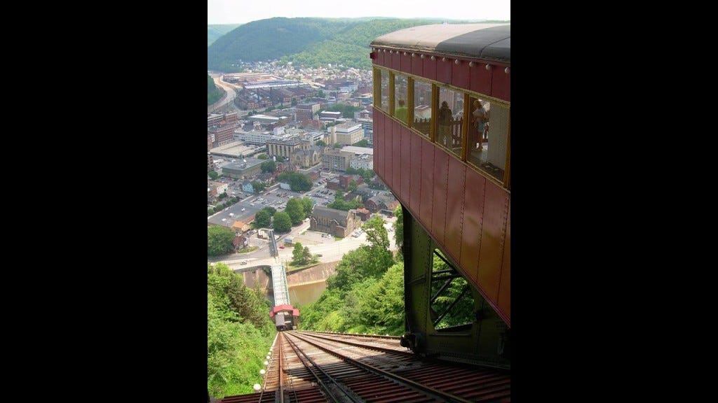
The Johnstown Inclined Plane was said to have been designed by Hungarian-American engineer Samuel Diescher, and completed in 1891 to serve as an escape route from floods in the valley at the confluence of the Conemaugh and Stonycreek Rivers, and to connect Johnstown with the Borough of Westmont on Yoder Hill.

Billed as the “World’s steepest vehicular inclined plane,” it’s slope has a grade of 71.9%, and it takes 90 seconds for it to travel in-between the two stations.
The Inclined Plane Railway back at Horseshoe Curve near Altoona was said to have been built in the 1990s to take tourists up to the park above to get a scenic view of the incredible engineering feat by the Pennsylvania Railroad circa 1854 of the Horseshoe Curve and its three-tracks that eliminated the need for the Allegheny Portage Railroad’s 10-incline planes.
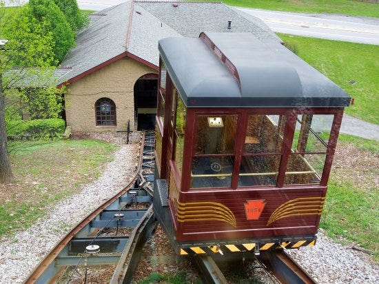
Incline railways work like an obliquely-angled elevator, in which cables attached to a pulley-system raise- and-lower the cars along the grade.
Two cars are paired at opposite-ends and act as each other’s counterweight. As such, there is not a need for traction between the wheels and rails, and thereby allowing them to scale steep slopes, unlike traditional rail-cars.
Thing is, there used to be way more of them than there are now, and inclined-railways were a worldwide thing.
Now they are mostly either tourist attractions, or kept in-service as an important part of a communities’ transportation infrastructure from low-ground to high-ground.

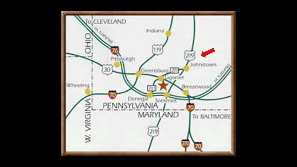
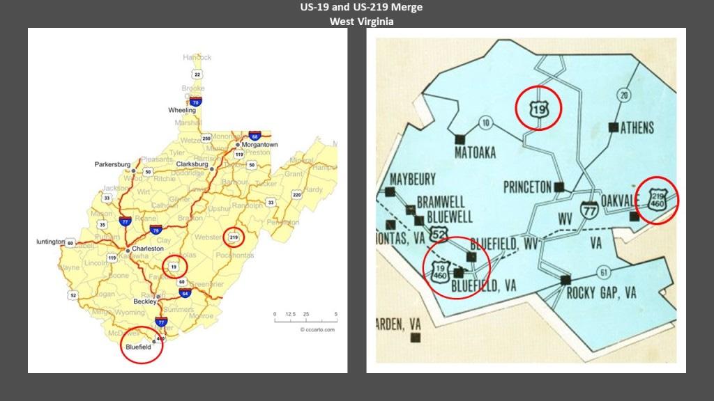
Back in Johnstown, come to find out that the main highway connecting Johnstown to the Pennsylvania Turnpike is US Route 219, which makes a lot of appearances here, as does US-19, and more on both to come in this post.
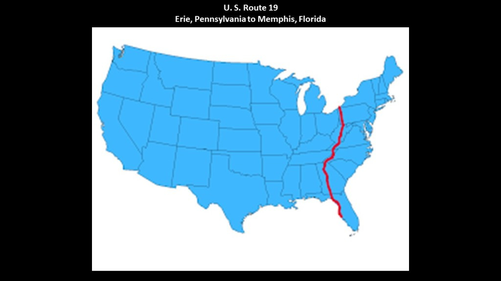
The North-South U. S. Route 19 runs from its northern terminus at U. S Route 20 at Lake Erie in Erie, Pennsylvania to its southern terminus at an interchange with U. S. 41 in Memphis, Florida, just south of St. Petersburg.
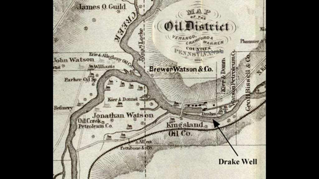
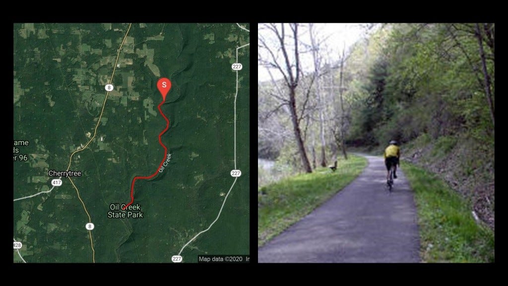
The petroleum industry in the United States began in earnest in 1859 when Edwin Drake found oil on a piece of leased-land near Titusville, Pennsylvania, in what is now called Oil Creek State Park.
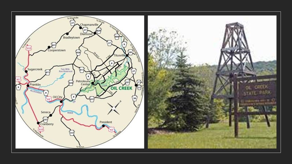
For this reason, Titusville is called the Birthplace of the Oil Industry, and for a number of years this part of Pennsylvania was the leading oil-producing region in the world.
Today, not surprisingly, the Oil Creek State Park Trail runs on the bed of the first railroad line to reach Titusville, the Oil Creek Railroad.
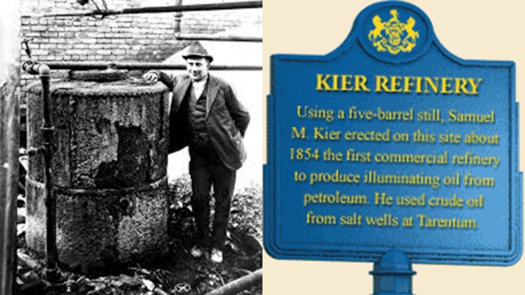
Samuel Kier had established America’s first oil refinery in Pittsburgh in 1854 for making lamp oil, just five-years before oil was “found” in Titusville.
So it certainly appears like the petroleum industry was developed in the 1850s in order to provide a replacement energy technology for the free energy technology of the original civilization.
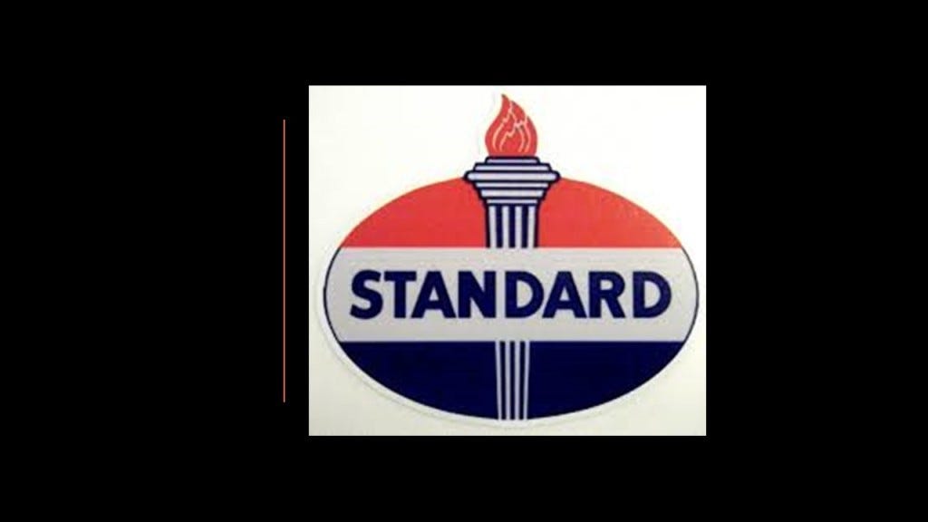
Roughly a decade after the birth of the oil Industry at Titusville in 1870, John D. Rockefeller, along with Henry Flagler, an American Industrialist and major developer in the state of Florida, founded the Standard Oil Company, an American oil producing, transporting, refining, and marketing company.
Oil was used in the form of kerosene throughout the country as a light source and heat source until the introduction of electricity, and as a fuel source for the automobile, with the first gas-powered automobile having been patented by Karl Benz in 1886.

John D. Rockefeller, who was born in the United States in 1839, was the progenitor of the wealthy Rockefeller family.
He was considered to be the wealthiest American of all time, as seen in this ranking by CNN Business, with an adjusted wealth of $253-billion.
Rockefeller’s wealth soared as kerosene and gasoline grew in importance.
At his peak, he controlled 90% of all oil.
As quickly as possible, a way was found to replace what remained of the free-energy system with their own coal- and oil-based system, and in the process make money hand over fist from the total control of the new system.

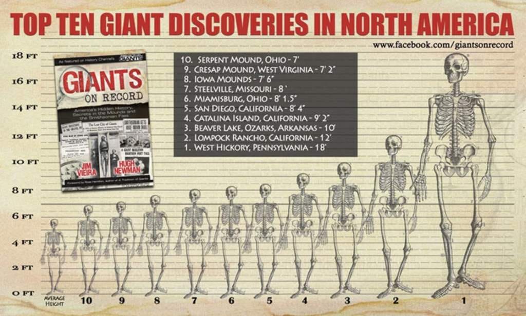
Interesting to note that West Hickory is the short distance ofjust 14-miles or 22-kilometers, south of Titusville, where the tallest recorded skeleton in North America was found at 18-feet, or 5.5-meters.
The previously-mentioned US Highway Route 19 goes through Pittsburgh.

Pittsburgh is the largest city in Appalachia and the Ohio Valley.
It developed as the vital link between theAtlantic Coast and the Midwest, with examples like the Allegheny Portage Railroad connecting the Pennsylvania Main Canal to Pittsburgh and the Ohio River and points west of the Allegheny Mountains.
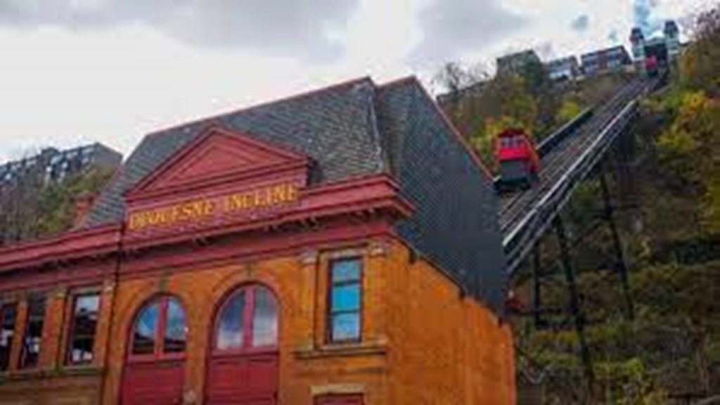
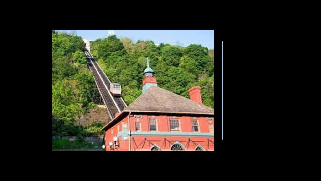
Samuel Diescher, who was credited with the design of the Johnstown Incline was also credited with the design of one of Pittsburgh’s two remaining inclines of the 17 that were originally on Mt. Washington – the Duquesne Incline, which opened in 1877.
It was closed in need of repairs in 1962, but reopened the next year after local residents raised funds to restore it, and it has been completely refurbished since then and is one of Pittsburgh’s most popular tourist attractions.
The Monongahela Incline on Mount Washington was said to have been designed by Prussian-born engineer John Endres of Cincinnati, Ohio, and started operating in 1870.
It is the oldest continuously operating funicular in the United States.
Interesting to note that 1870, the same year the Monongahela Incline became operational in Pittsburgh, was also the same year John D. Rockefeller and Henry Flagler, founded the Standard Oil Company.
Pittsburgh played a dominant role in the development of the U. S. Steel Industry.

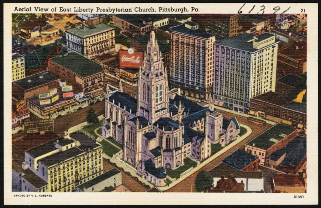
Many leading industrialists of the 19th-century were based in Pittsburgh, and resided in the East Liberty neighborhood in Pittsburgh’s East End, at one time the richest suburb in America, with names including Mellon, Carnegie, Heinz, and Westinghouse living there.
We are told that East Liberty started developing as a commercial area in 1842, when Thomas Mellon, prominent businessman and patriarch of the Mellon family in Pittsburgh, married Sarah Jane Negley, daughter of one of the earliest land-owners in the area, and made East Liberty their home..
We are told that Thomas Mellon made his fortune selling or rented land inherited by his wife, and used the proceeds to finance early industries in Pittsburgh.

Once again in 1870, he and his sons Andrew and Richard established the “T. Mellon & Sons Bank,” and it became the Mellon National Bank In 1902.
It became a force in the mass production revolution in the United States, particularly in the Midwest.
A National Bank is a private bank operating as a commercial bank within the Federal Government’s Regulatory Structure, and under the supervision of the “Office of the Comptroller of the Currency,” rather than a state banking agency.
At one time in our history, National Banks had the authority to print money.
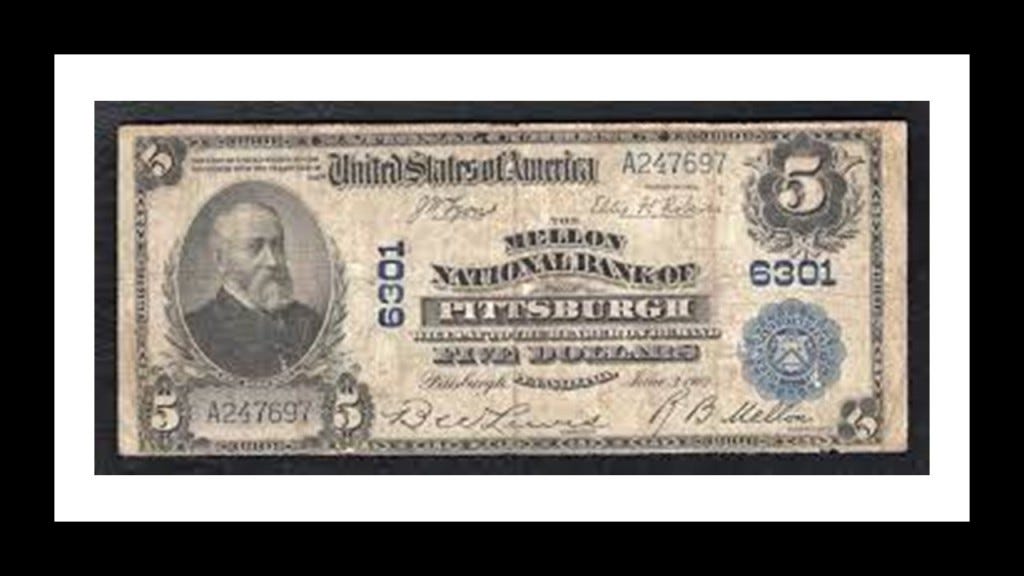
At its height, Mellon Financial Services was one of the world’s largest money management firms.
It merged with the Bank of New York in 2007 to become BNY Mellon.

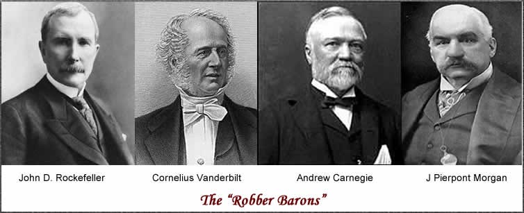
Richard Mellon, with an adjusted wealth of $103-billion, is listed as the 5th wealthiest American of all-time by CNN Business, and a founder of Gulf Oil and Alcoa Aluminum, as well as a number of other big corporations, along with his brother…

…Andrew Mellon, who is listed as the 15th-wealthiest American of all-time by CNN Business, with an adjusted wealth of $63.2-billion.

It is important to note that Andrew Mellon was an acknowledged Freemason, and also the U. S. Secretary of the Treasury from March 9th of 1921 to February 12th of 1932, presiding over the Boom years of the 1920s as well as the Wall Street Crash of October 1929, which led directly to the Great Depression.

Andrew Mellon was also a close friend of Henry Clay Frick, and a member of the South Fork Fishing and Hunting Club, along with Andrew Carnegie, on the property where the dam failed that caused the Johnstown Flood, as previously discussed.
Along with Andrew Mellon, as we saw earlier in the section on Johnstown, Andrew Carnegie and Henry Clay Frick were initiated into Freemasonry, with Henry Clay Frick active for only five-years, but supported Freemasonry his entire life.

It’s important to note that with the philanthropic activities spoken of these extremely wealthy men, which are made to sound extremely benevolent and meant to benefit Humanity, it seems like their intent was highly questionable as to their actual motives.
We have seen or referenced all four of these men who receive the top billing as “Robber Barons,” and more on Morgan to come.
Among many other things, both the Rockefeller and Carnegie Foundations have been highly involved in the American Educational System.

Even as early as 1914, the National Education Association expressed alarm at the activity of the Carnegie and Rockefeller Foundations, and their efforts to control the policies of State educational institutions, and everything related to the educational system.

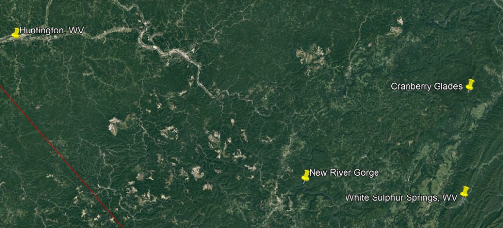
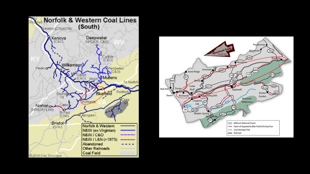
Now I’m going to go back to US-219 that we saw in Johnstown and take it on down to where it ends at Bluefield, Virginia, right across the state border from Bluefield, West Virginia, where it meets up with US-19.
The land beneath the two Bluefields contains the richest deposit of bituminous coal in the world, known as the “Pocahontas Coalfield,” or the “Flat-Top Pocahontas Coalfield,” named after the Flat Top Mountain on US-19 in West Virginia, and Pocahontas, Virginia, where the first coal-seam here was discovered.
The Pocahontas Coalfield started to be mined in 1882.

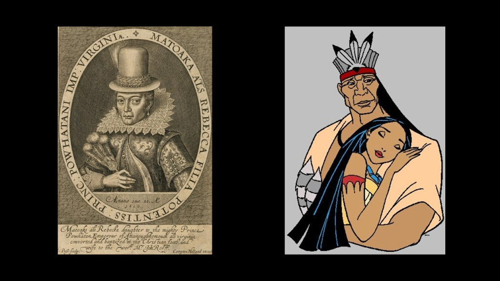
Pocahontas in Virginia was named after the famous daughter of Chief Powhatan in connection with the 17th-century Jamestown Colony, the first permanent English settlement in the Americas.
This is the most famous depiction of Pocahontas from her time on the left, but this how we have been taught to see Pocahontas and Powhatan on the right.
We are told that Bluefield in West Virginia, with its great location with respect to the developing Pocahontas Coalfield, was selected as the location of a major Division point on the Norfolk and Western Railway in the late 19th-century, and that the railroad greatly stimulated the town’s growth, so much so that in its hey-day, Bluefield was considered a “Little New York.”
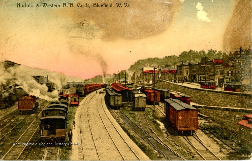
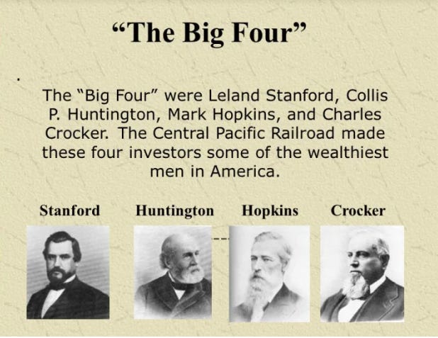
The Chesapeake and Ohio Railway was formed in 1869 from several smaller Virginia Railroads under the guidance of Collis P. Huntington also around the same time that the Standard Oil Company was founded, in order to connect the coal reserves of West Virginia with the new coal piers that were built in Hampton Roads and Newport News, Virginia, and first opened in 1873, forging a rail link to places like Chicago in the Midwest.

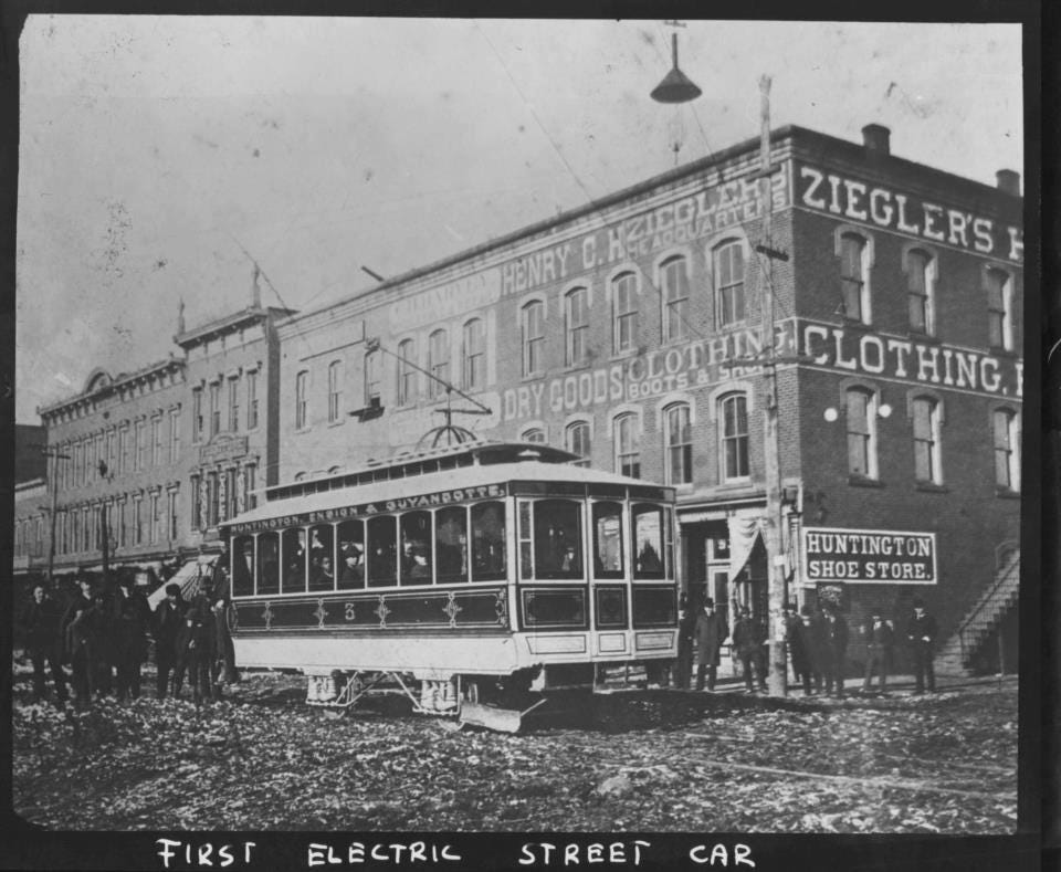
The city of Huntington in West Virginia was named for him.
Huntington was said to be one of the first American cities to have electric streetcars, with service believed to have started around the end of 1888, and ran until the 1920s, during which time the Ohio Valley Electric Railway had organized a gas-powered bus service, which by November 1937 had completely replaced all of Huntington’s former electric streetcar lines.
Collis P. Huntington was one of the Big Four of western railroading, along with Leland Stanford, Mark Hopkins and Charles Crocker.
We are told that after the Chesapeake and Ohio Railway opened up the New River Gorge region in 1873, coal was carried out of the New River Gorge to the ports in Virginia and to cities in the Midwest.
As a result, by 1905, thirteen cities sprang up between Fayette and Thurmond, which was 15-miles, or 24-kilometers, upstream, and provided the West Virginia coal that contributed greatly to the industrialization of the United States until the 1950s.
After the coal seams were exhausted and mines closed, these company towns were for the most part completely abandoned, with the possible exception of Thurmond which had a very small population of 5 in 2010.

It is interesting to note that at one time in its history, Thurmond was a prosperous railroad town that was the largest, revenue-generating stop on the C & O Railroad, where passenger and coal trains rolled through here throughout the day.
Today, a visitor center for the National Park Service operates here in the old railroad depot.
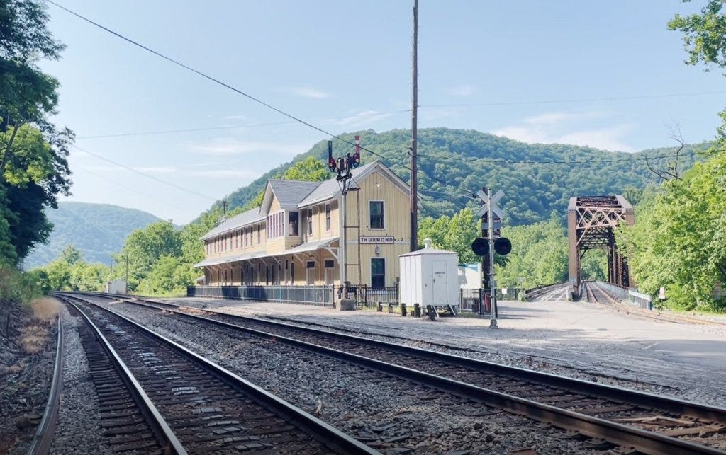
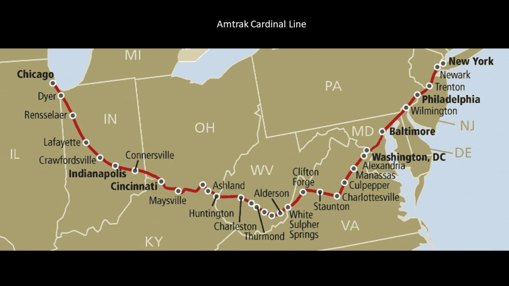
CSX Transportation, formerly the C & O Railroad, has freight transportation operations in and through historic Thurmond, and the Amtrak Cardinal passenger route goes through here, the second-least-used Amtrak station in the nation.
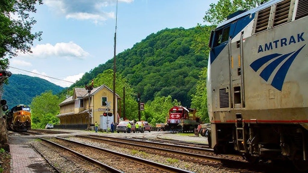
As a matter of fact, the New River Gorge is one of the places that I know of that still has a railroad operating right along beside the S-shaped New River.
The Amtrak Cardinal still runs through the New River Gorge 3 days/week – on Sundays, Wednesdays and Fridays.
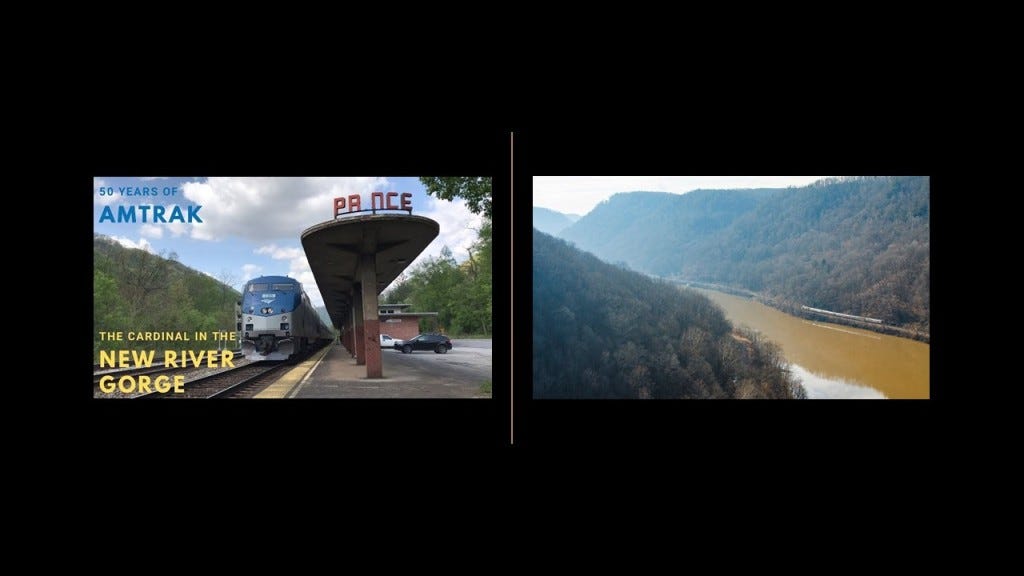
So like we saw back at the Lehigh Gorge in Pennsylvania with its railroad running alongside the river; the waterfalls; and the coal-mining in the region, we find the same things here at the New River Gorge in West Virginia.
Besides the railroad line that runs along the New River through the New River Gorge in West Virginia, there are things found in the gorge like historic coal mines, waterfalls, and hydro projects.

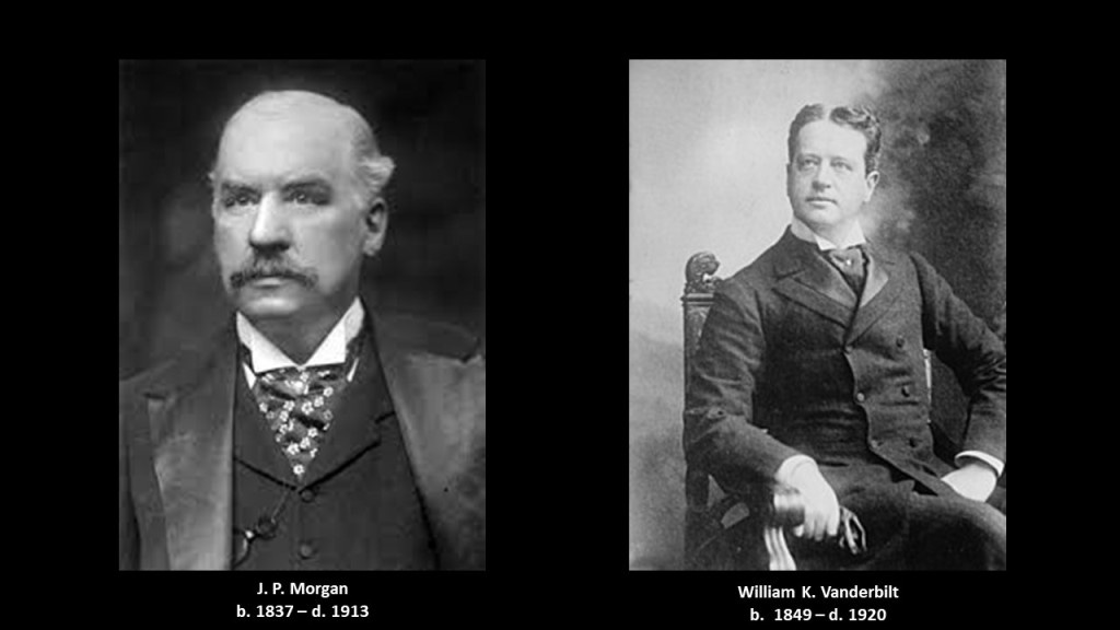
In 1888, Collis P. Huntington lost control of the railroad to J. P. Morgan, an American financier and investment banker who dominated corporate finance on Wall Street during the Gilded Age between 1877 and 1900, and William K. Vanderbilt, who managed the Vanderbilt family’s railroad investments.
William K. Vanderbilt was was the grandson of Cornelius Vanderbilt.
The process continued on for the C & O Railroad to consolidate and merge railroads, and, for example, to gain access to productive coal fields throughout the region, through the 1920s.
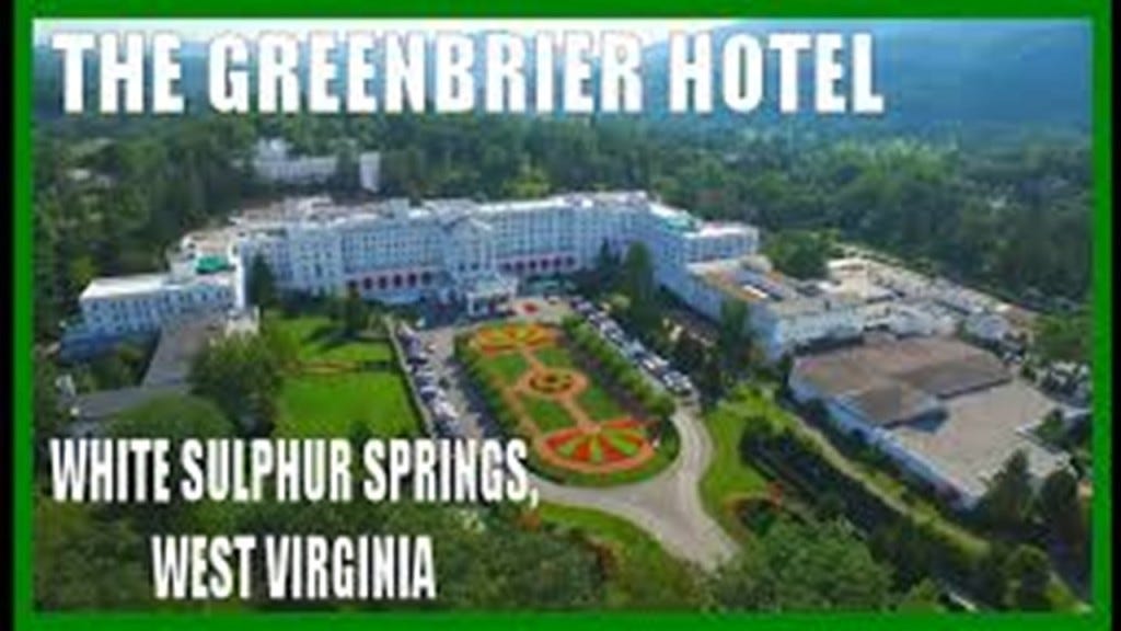
Next I am going to take a look at White Sulphur Springs, West Virginia, which is to the southeast of the New River Gorge and to the northeast of the Pocahontas Coalfield region.

White Sulphur Springs was said to have been settled in 1750, and developed as a health spa in the 1770s, as the story goes after a woman was healed of rheumatism after bathing in the springs, and calls itself “America’s Resort since 1778.”
The springs are on the grounds of the Greenbrier Hotel and resort, which was said to have been built by the Chesapeake & Ohio Railroad Company in 1913.
Even today, the same Amtrak Cardinal Line that runs through the New River Gorge has a station at White Sulphur Springs.

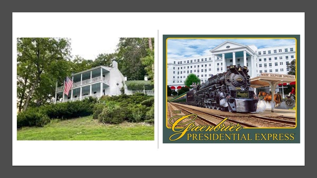
The Greenbrier Resort was at one time a Presidential getaway, with President Eisenhower the last President in office to have stayed there, with 27 presidents having stayed at the hotel before him.
The Presidents’ Cottage is a museum today.
A top-secret, super-sized underground bunker was said to have been constructed there in the 1950s during the Eisenhower Administration to serve as a relocation point for the U. S. Congress in the event of a nuclear war, but when the secret came out in 1992 in a newspaper article, it was decommissioned.
It had features like:
–A 25-ton blast door that opened with only 50-lbs of pressure
–It’s own power plant with purification equipment, and the capacity for 75,000-gallons of water storage, and 42,000-gallons of diesel fuel
–Every kind of medical care one would ever need
–Sleeping, meeting, and eating facilities for over 1,000 people.
It was kept stocked with supplies for thirty-years but never used as an emergency location.
In 1995, the government ended the lease agreement with the Greenbrier, and it was opened to the public for tours, which it offers to this day.

Today’s Amtrak Cardinal Line runs between New York and Chicago, by way of Washington, DC; through White Sulphur Springs, Cincinnati, and Indianapolis, on its meandering route, and was once part of the Chesapeake and Ohio Railroad.
Burke’s Garden in Virginia is just to the south of the Bluefield area, is accessed from US-19, and the next place I want to bring to your attention.

Burke’s Garden has a population of about 300 people, in a place considered to have the most fertile soil in Virginia, but no post office; no cell phone or cable service; cool-to-cold weather; and one paved road to Tazewell, the nearest town about 15-miles, or 23-kilometers away.
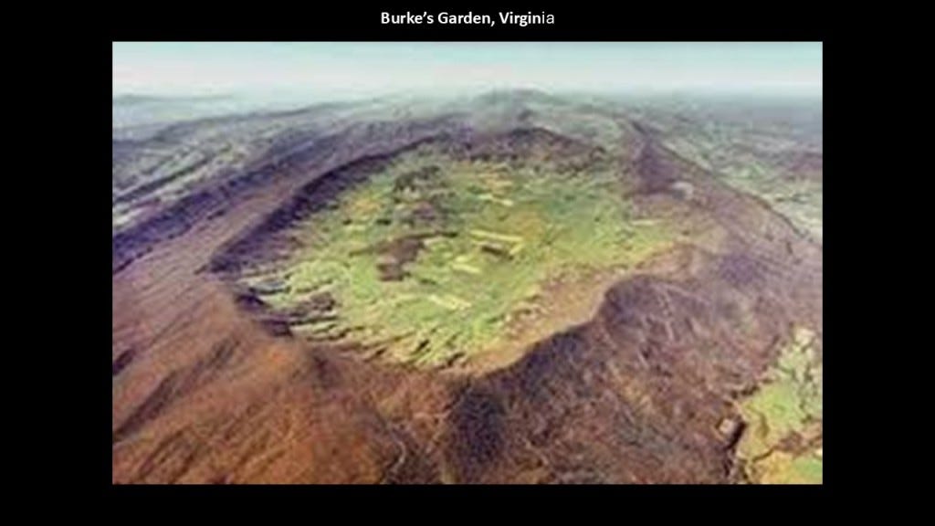
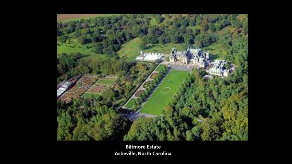
Burke’s Garden was known as “Vanderbilt’s First Choice” for the Grand Biltmore Estate.
We are told that the land-owners there wouldn’t sell to George Vanderbilt II, so he went to Asheville in North Carolina instead.
More on Asheville shortly.

There are a number of historic railroads in the vicinity of Burke’s Garden, like the Norfolk & Western Railroad’s Clinch Valley Line between the coalfields of Bluefield running through Tazewell County beside US-19 to the high-quality coalfields of the Clinch River Valley south of Richlands.
The last place I want mention on US-19 is Asheville in North Carolina.
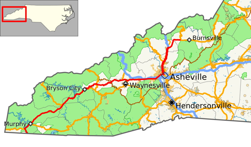
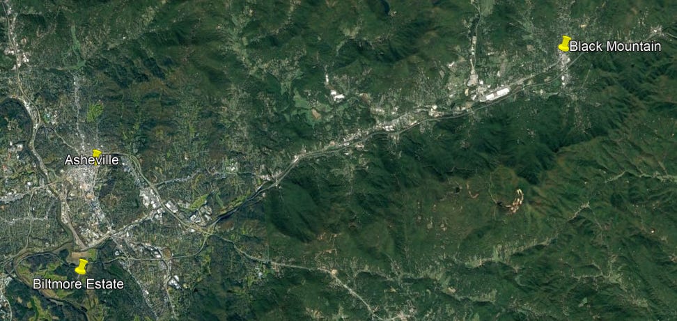
Asheville is at the confluence of the French Broad and Swannanoa Rivers.
George Vanderbilt II’s Biltmore Estate is divided by the French Broad River, and its confluence with the Swannanoa River is on the Biltmore Estate.
This whole region was part of the traditional lands of the Cherokee people.
They were said to have ceded their land here around Asheville 1819.
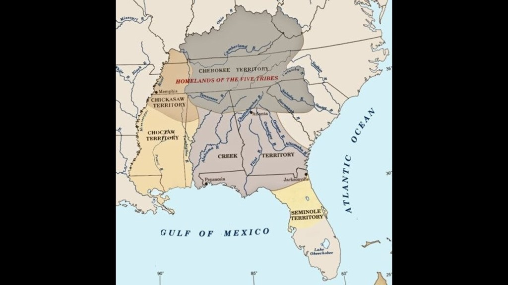
The Cherokee were one of the five civilized tribes to be forcibly removed from their land after the Indian Removal Act of 1830 was passed by Congress, and enforced by Lewis Cass, Andrew Jackson’s Secretary of War, and the Cherokee were marched west to Indian Territory in one of several Trails of Tears.

So Asheville on US-19 ended up being the location chosen by George Vanderbilt II for the Biltmore Estate instead of his “first choice” Burkes Garden, also on US-19.
The Biltmore Estate is on 8,000-acres, or 3,237-hectares of land.
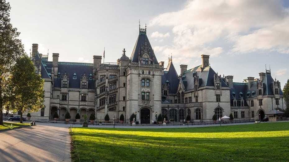
This is what we are told about the Biltmore.
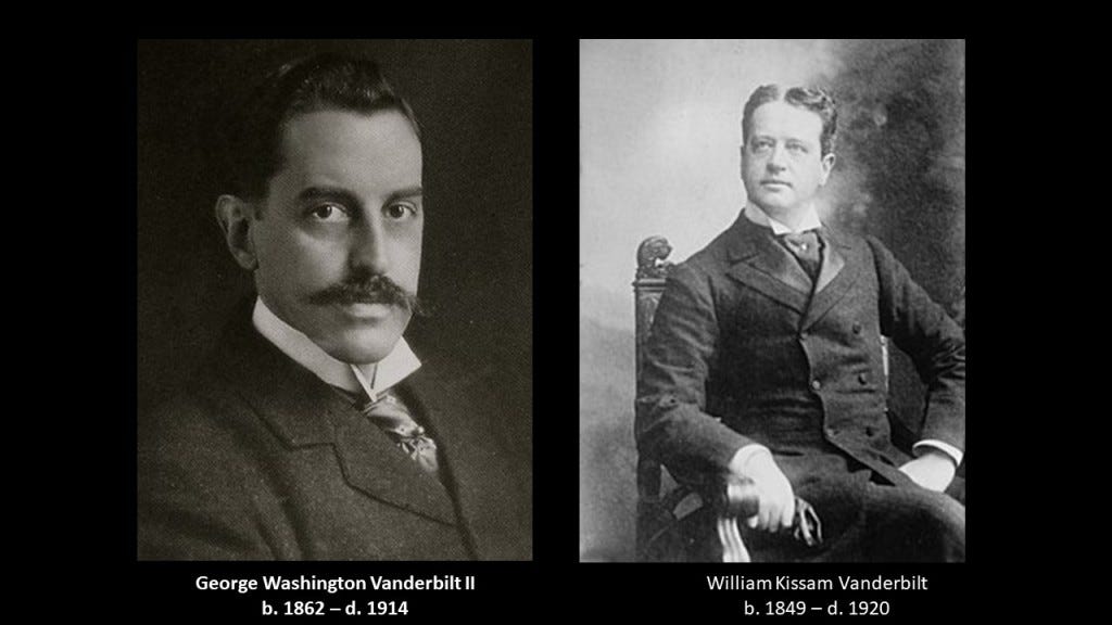
It was said to have been a Chateauesque-style mansion, meaning in the revivalist Renaissance architectural-style of French chateaux of the Loire Valley, built for George Washington Vanderbilt II between 1885 and 1895.
It is the largest privately-owned residence in the United States, and is considered one of the most prominent of the Gilded Age mansions.
The Gilded Age is the name given to the period of time in American history between 1877 and 1900, a time of rapid industrialization and rapid economic expansion.
This would have roughly corresponded in our historical narrative to the Reconstruction Era after the American Civil War, which we are told ended in 1865, and the Progressive Era, which is what we are told was a period of widespread political activism and reform, that started in 1896.
It was also a time when the contrast of the ostentatiousness of the wealthy versus the abject poverty of the working class became more visible.
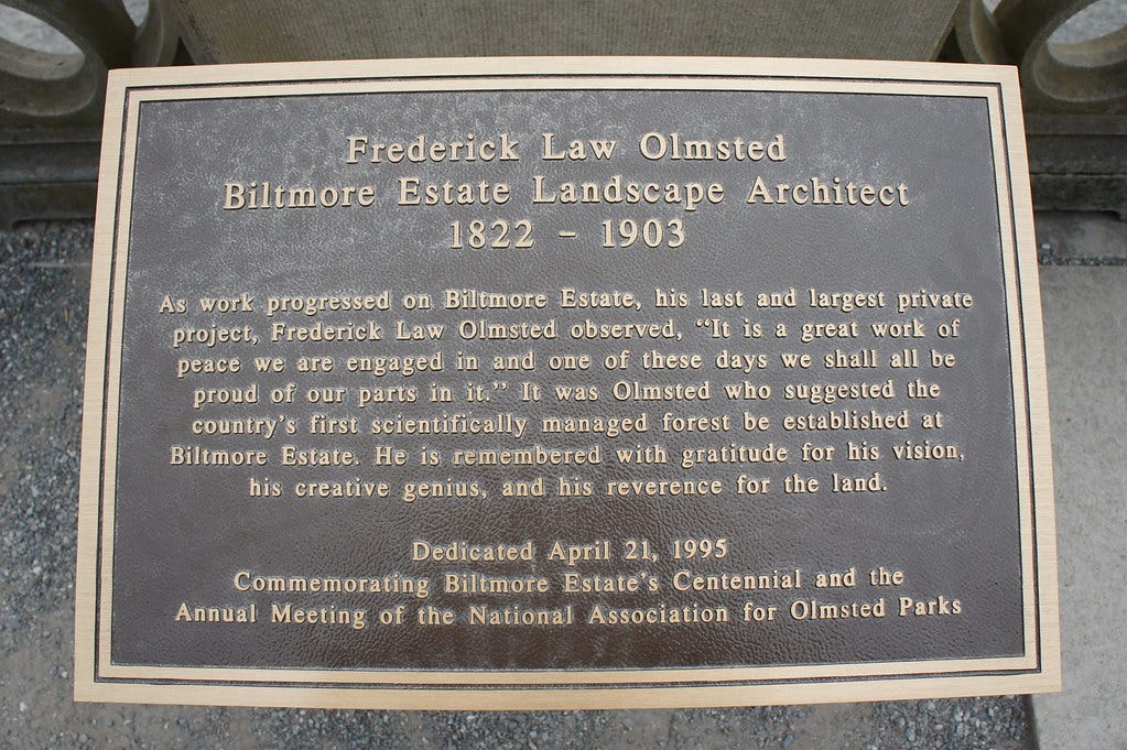
We are told that the famous landscape architect Frederick Law Olmsted was employed by George Washington Vanderbilt II to design the landscape for the Biltmore Estate.
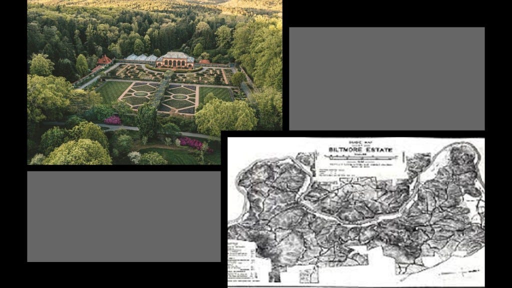
It was said to be Frederick Law Olmsted’s last project, and he was memorialized in a plaque there.
George Washington Vanderbilt II was William Kissam Vanderbilt’s brother, who was mentioned earlier in this post as having gained control of the Chesapeake & Ohio Railroad, along with financier J. P. Morgan, from Collis Huntington in 1888.
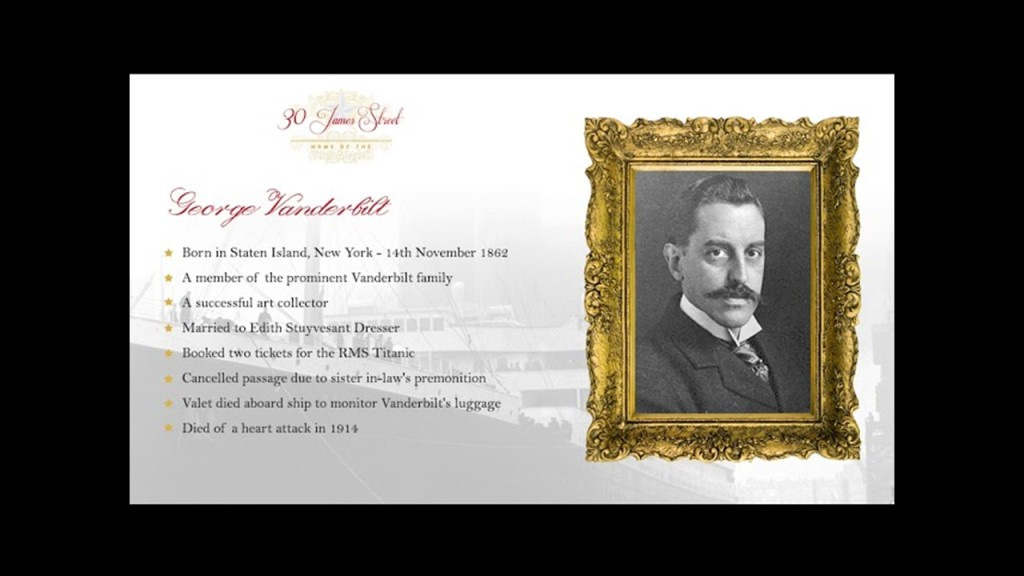
What we are told in our historical narrative is that George W. Vanderbilt II was supposed to sail on the RMS Titanic with his wife but they changed plans at the last minute.
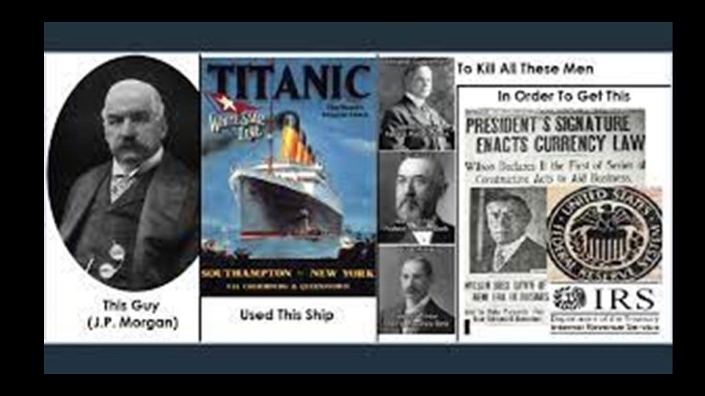
J. P. Morgan has long been suspected of having been behind what has come down to us as the sinking of the Titanic.
This is what we are told on the Federal Reserve History website.
A secret meeting took place on Jekyll Island off the coast of the State of Georgia to lay the foundations of the Federal Reserve between November 20th and November 30th of 1910.

The purpose of the meeting was so secret that what the six men talked about was a closely guarded secret for many years, and they did not admit to it until the 1930s.

They were laying the foundation for what would become the Federal Reserve System.

Again, this information is from the Federal Reserve History website.
J. P. Morgan was a member of the exclusive Jekyll Island Club, was likely the one who arranged for the group to use the club’s facilities.
George’s brother, William K. Vanderbilt was also member of what Munsey’s Magazine described in 1904 as the “richest, most exclusive, and the most inaccessible” club in the world.
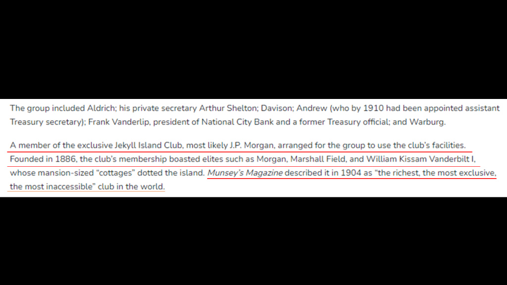
Arriving on a private train car, the group of men who attended the 10-day secret meeting on Jekyll Island in November of 1910 adopted the cover story of a “duck hunt” to explain their activities and hide the true purpose of their meeting, and addressed each other by their first names only – hence they adopted the name of the “First Name Club.”

This was the train station in Brunswick that serviced Jekyll Island on the Southern and Atlantic Coast Railroad.
The Oglethorpe Hotel pictured here was said to have opened in January of 1888, after having been built on top of the previous Oglethorpe House which was said to have burned down during the Civil War.
It remained in operation until 1958, at which time it was torn down and replaced by a Holiday Inn.

The Holiday Inn was eventually torn down too, leaving an empty lot in downtown Brunswick called the “Oglethorpe Block.”

Then, on April 15th of 1912, we are told the Titanic sank. with all the bankers opposed to the creation of the Federal Reserve on board, including John Jacob Astor IV, one of the richest people in the world at the time.

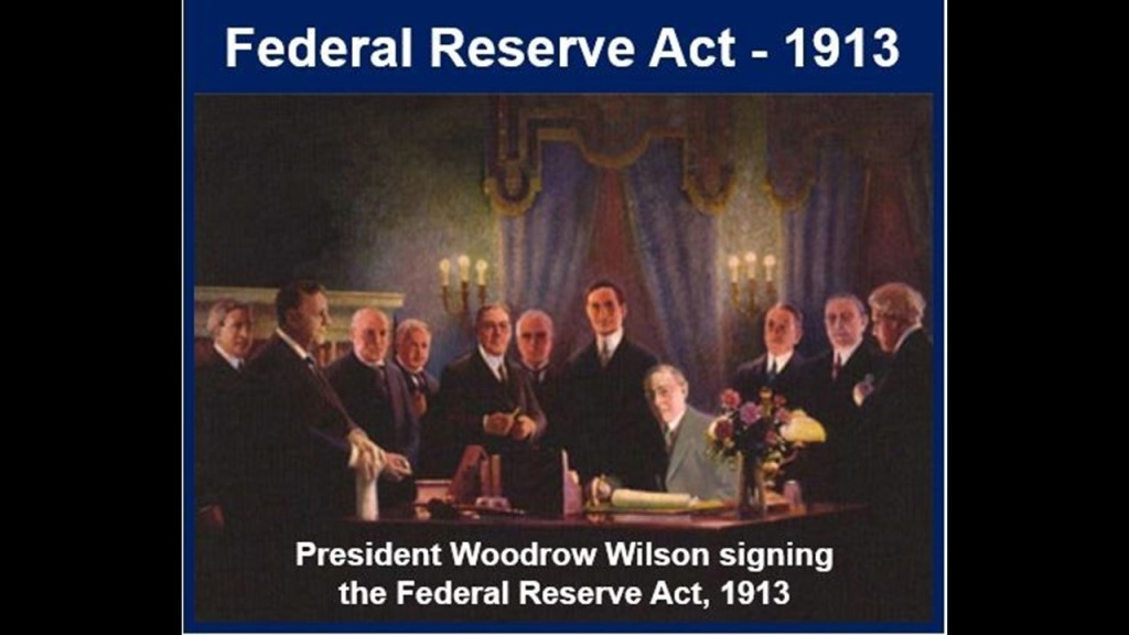
The following year, on December 23rd, 1913, the Federal Reserve Act Passed Congress, signed into law by Woodrow Wilson. It created and established the Federal Reserve System, and created the authority to issue Federal Reserve Notes (commonly known as the US dollar) as legal tender.
John Jacob Astor IV was the great grandson of the previously-mentioned John Jacob Astor, who made a fortune in real estate development, the fur trade, and opium smuggling.
John Jacob Astor was considered to be the world’s first multi-millionaire, and the third-richest American of all time according to CNN Business, with an adjusted wealth of $138-billion.

J. P. Morgan himself didn’t make the CNN Business List of the 20 wealthiest Americans of all time, but he dominated corporate finance on Wall Street throughout the “Gilded Age,” and was a major driving force behind the wave of industrial consolidation in the United States in the late 19th- and early 20th-centuries, like the previously mentioned U. S. Steel in 1901.
J. P. Morgan’s father, Junius Spencer Morgan, was the founder of the company that would become J. S. Morgan & Company in 1864, that was the successor company to George Peabody & Company, of which he became the Junior Partner in October of 1854.
In 1854, Morgan was put in charge of the firm’s iron portfolio, which included the marketing of railroad bonds in London and New York.
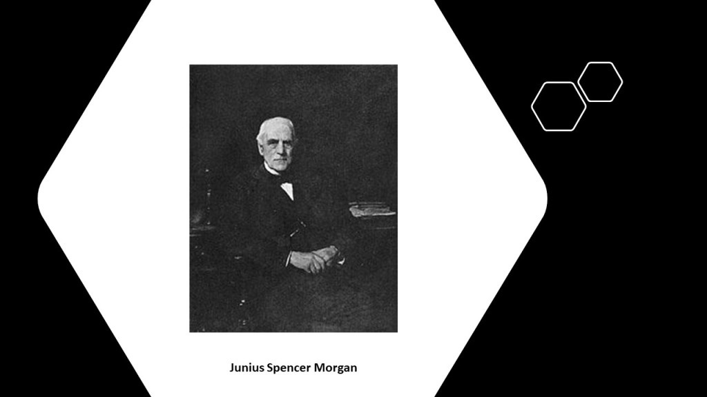
By the time J. S. Morgan died in 1890, the Morgan banks were the dominant forces in government and railroad finance, and his son John Pierpont Morgan had taken the helm of the company, becoming known as. J. P. Morgan & Company in 1895, now known as JP Morgan Chase & Company.

George Peabody’s bank became the premier American banking house in London after he took up residence from Baltimore to London permanently in 1837, and went from being a wholesale dry-goods and cotton merchant, to a merchant-banker offering securities in American railroad and canal enterprises to British and European investors.
He started a banking business trading on his own account a year after he moved to London, and by 1851, he established the banking firm of “George Peabody & Company” to meet the increasing demand for securities issued by American railroads, and his company specialized in financing governments and large companies.

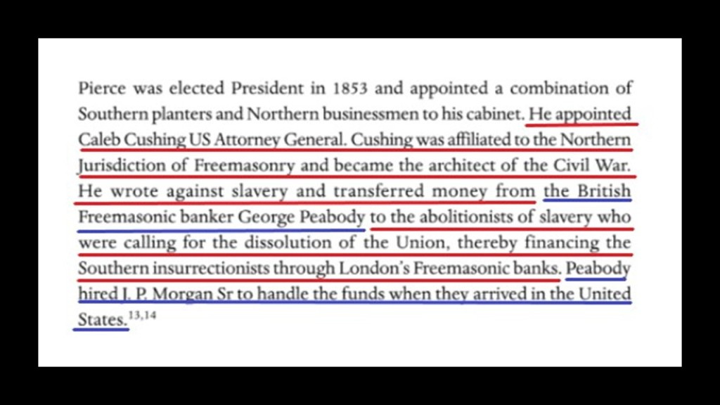
According to “The Secret Founding of America” book by Nicholas Hagger…

…George Peabody was the Freemasonic banker from whom money was transferred to the “southern insurrectionists,” and he hired the father of J. P. Morgan to handle the funds when they arrived in the United States.
Banker George Peabody established the Peabody Institute in Baltimore in 1857 with a bequest of at least $800,000, and it is the oldest conservatory in the United States.
By the time it was completed and opened in 1866, one year after the official end of American Civil War, it was dedicated by George Peabody himself,and included a music academy, library and art gallery.
George Peabody was also called the “Father of Modern Philanthropy.”
That entrance at the east wing of the George Peabody Library sure looks proportionally like its made for much bigger people than we are today!

So, exactly how do you go about hiding giants and their advanced civilization?
I think the American Civil War was one of many ways to do this, and that it was not what we are told it was about.
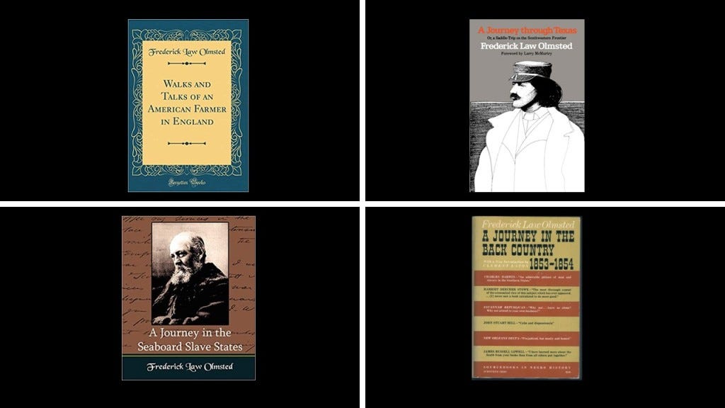
The revered and seemingly prolific Frederick Law Olmsted started out his career as a journalist.
Among other things, during the pre-Civil War time period, Olmsted was commissioned by the New York Daily Times to start on an extensive research journey in the American South and Texas between 1852 and 1857.
He published three books from this time into one book, called “Journeys and Explorations in the Cotton Kingdom,” in 1861 during the first six months of the American Civil War at the suggestion of his English publisher.
All of these books by Frederick Law Olmsted raise red flags for me, as I have come to believe from my research that publications like these are indicative of some kind of setting the stage in seeding the new historical narrative into our consciousness by those responsible for the hijack of the original positive civilization that built all of Earth’s infrastructure.
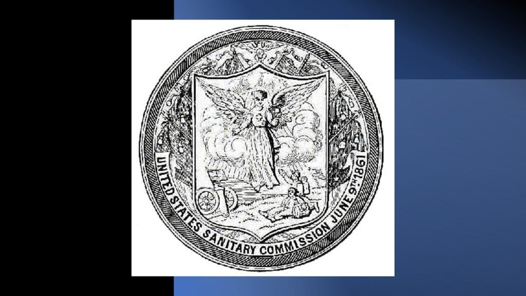
Frederick Law Olmsted was also the first executive secretary of the United States Sanitary Commission as well as an organizer of the Union League.
First, the United States Sanitary Commission.
What we are told about the United States Sanitary Commission is that it organized “Sanitary Fairs” during the American Civil War as a fundraiser for the many needs of Union Soldiers, including health.
“Sanitary Fairs” had everything, including majestic “temporary” buildings said to have been built for the fairs, to be torn down after, and while not as elaborate as the big expositions such as in Chicago, they were still something in and of themselves.

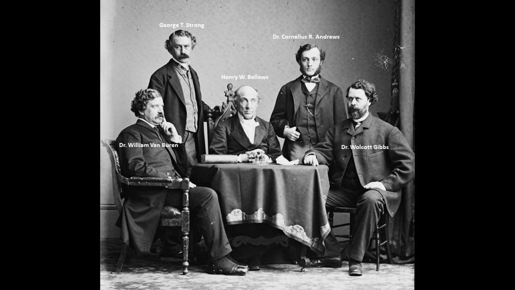
Frederick Law Olmsted was on the standing committee for the United States Sanitary Commission that was formed in New York, with its main members throughout the Civil War also consisting of: Henry Whitney Bellows; George Templeton Strong; and surgeons Dr. William H. Van Buren, Dr. Cornelius R. Agnew, and Dr. Wolcott Gibbs.
Did the U. S. Sanitary Commission and its volunteers really have the wherewithal to both construct the buildings for and pull off these extraordinarily lavish and festive undertakings against the backdrop of national war and suffering?
Or was it a private front comprised of the very same people who organized and were prominent members of the private membership clubs of the day, like the Union League and the Century Association.
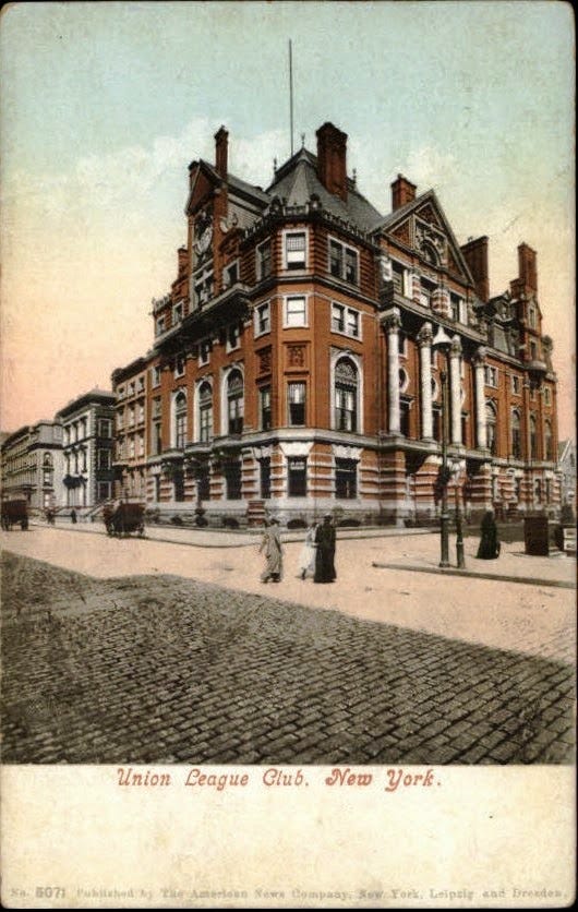
We are told the Union League was a private social club for wealthy men that opened in New York City in 1863 for pro-Union men could come together “to cultivate a profound national devotion” and “strengthen a love and respect for the Union.”
It became the most exclusive mens’ club in Manhattan, and perhaps in the nation.
This location for the Union League Club was said to have been built on the northeast corner of 5th Avenue and 39th Street between 1879 and 1881.
Along with Frederick Law Olmsted, organizers of the Union League Club were Henry Whitney Bellows, George Templeton Strong, and Wolcott Gibbs, same names as the United States Sanitary Commission.
Henry Whitney Bellows was also involved in the organizing of the Century Association in New York City, founded in 1847 and incorporated in 1857.
The Century Association was a private social, arts and dining club, and named after the first 100 people proposed as members.
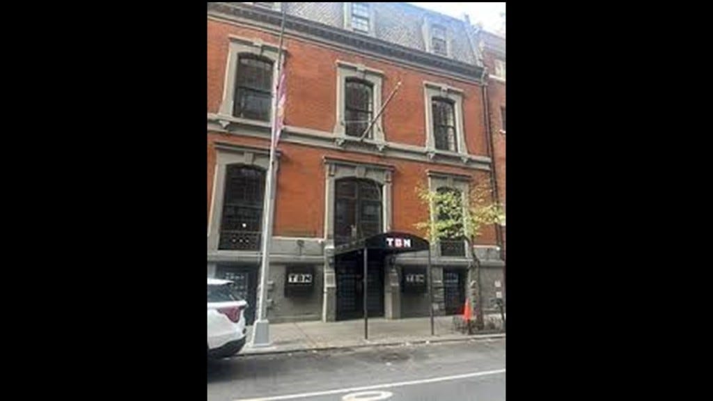
The Century Association Building at 42 E. 15th Street was in-use by the association starting in 1857, and which served as one of the headquarters of the United States Sanitary Commission.
Members of the Century Association have included artists and writers like: poet and journalist William Cullen Bryant; landscape painter Frederick Edwin Church; landscape painter Winslow Homer; and best-known for stained-glass-work, Louis Comfort Tiffany.
Architect members have included: landscape-architects Calvert Vaux and Frederick Law Olmsted; Beaux-Arts architects Carrere and Hastings, as well as York and Sawyer; and architects McKim, Meade and White, who were said to have defined the ideals of the American Renaissance in end-of-the-century New York.
Other members were said to have included: Eight U. S. Presidents; ten U. S. Supreme Court Justices; forty-three Members of the Presidential Cabinet; twenty-nine Nobel Prize Laureates; members of the Rockefeller, Vanderbilt, Roosevelt, and Astor families; as well as financier J. P. Morgan and morse code inventor Samuel P. Morse.
Ever hear the George Carlin quote “It’s one big club, and you ain’t in it?” and wonder where that idea might have come from?
Seems like all of these private clubs we are seeing in this post were private and exclusive for a reason, and that was to secretly plan their activities and next moves that no one is supposed to know about!

The so-called elites have continued doing the same thing to this day in their secretive meetings to plan their agendas for what they want the future to look like for Humanity and the World, and what they want doesn’t look good for us!

The United States Sanitary Commission and the Sanitary Fairs and the exclusive private clubs associated with the very same people leads to the larger question, of what was really going on during the American Civil War, historically described as a civil war between northern states, or “Union,” and the southern states, or “Confederacy,” over the status of slavery and its expansion into newly acquired land after the Mexican-American War.

We are told there were three theaters of war during years of American Civil War, between 1861 and 1865: Eastern, Western, and Trans-Mississippi.
I have often thought that theater, defined as a collaborative form of performing art that uses live performers, usually actors or actresses, to present the experience of a real or imagined event before a live audience in a specific place, like a stage, is a thought-provoking word choice for an area or place in which important military events occur or are progressing.

I have come to view the American Civil War as Freemasonic Theater, which I think applies to all the wars and armed conflicts of our modern era.
Orphan trains started in 1854, under the auspices of Frederick Law Olmsted’s good friend, Charles Loring Brace, and the Children’s Aid Society, which Brace established in 1853.
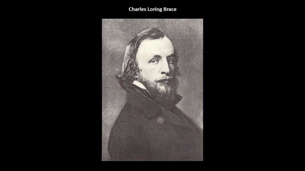
A new experimental program of his called “placing-out” became known to us as “Orphan Trains,” and for the next 75-years, over 200,000 children were sent across the continent, to uncertain destinations and uncertain futures with strangers.

A movement going in this direction was widely supported by wealthy New York families, like Charlotte Augusta Gibbes, the wife of John Jacob Astor III, grandson of John Jacob Astor, and who was the wealthiest Astor family member of his generation.

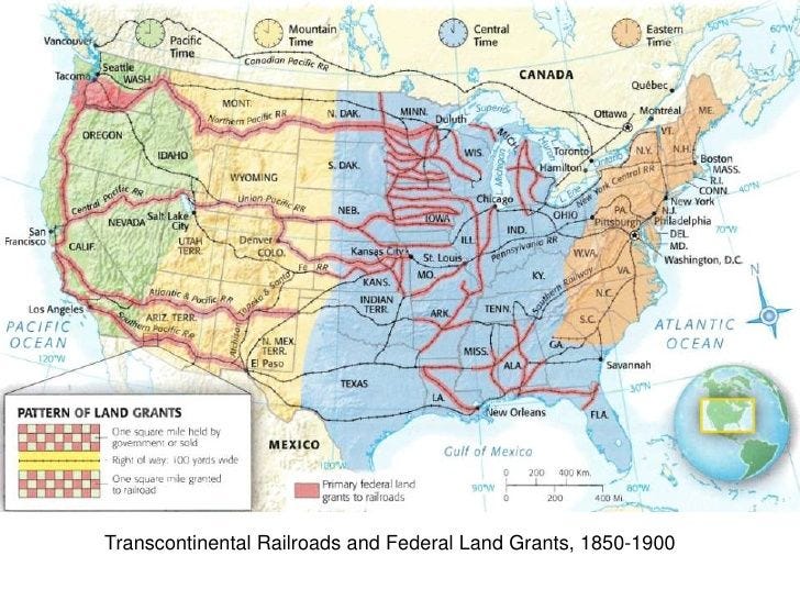
Right around the same time as the beginning of the Orphan Train Movement, and the alleged completion of the Horseshoe Curve by the Pennsylvania Railroad near Altoona, both taking place in 1854, we are told that the federal government operated a land-grant system between 1855 and 1871, where new railway companies in what we are told was the uninhabited west were given millions of acres they could sell or pledge to bondholders.
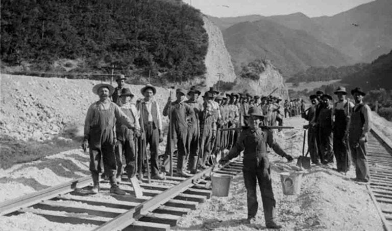
The establishment of a land-grant system at this time is a good place to insert once again the story of the Ames Brothers of Easton, Massachusetts, co-owners of the Ames Shovel Shop, nationally known for providing the shovels for the Union Pacific Railroad, which we are told opened the West.
It was said to have been the world’s largest supplier of shovels in the 19th-century.
Why were shovels so important to the opening of the West and the expansion of infrastructure?
What if…the tracks were already there and just needed to be dug out?
Not only that, one brother, Oliver Ames, Jr, was the President of the Union Pacific Railroad from when it met the Central Pacific Railroad in Utah for the completion of the first Transcontinental Railroad in North America.
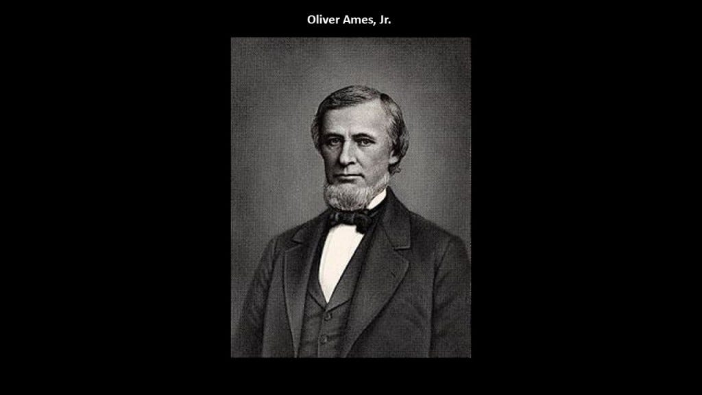
The other brother, Oakes Ames, was a member of the U. S. Congress House of Representatives from Massachusetts 2nd District from 1863-1873.
He was credited by many as being the most important influence in building the Union Pacific portion of the first Transcontinental Railroad.
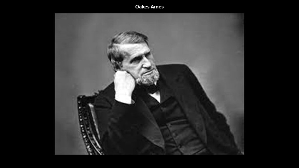
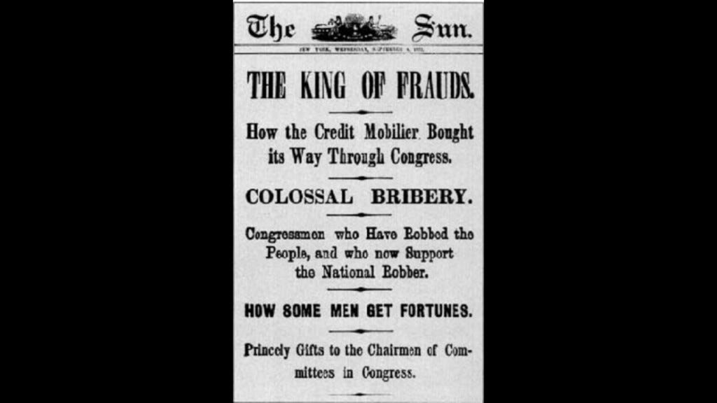
Oakes Ames was also noteworthy for his involvement in the Credit-Mobilier Scandal of 1867, regarding the improper sale of stock of the railroad’s construction company.
He was formally censured by Congress in 1873 for this involvement, and he died in the same year.
Ten-years later, he was posthumously exonerated by the Massachusetts State Legislature on May 10th, 1883.
The cities of Ames, Iowa, and Ames, Nebraska, are both said to be named for Oakes Ames, and were stops on the Union Pacific Railroad.
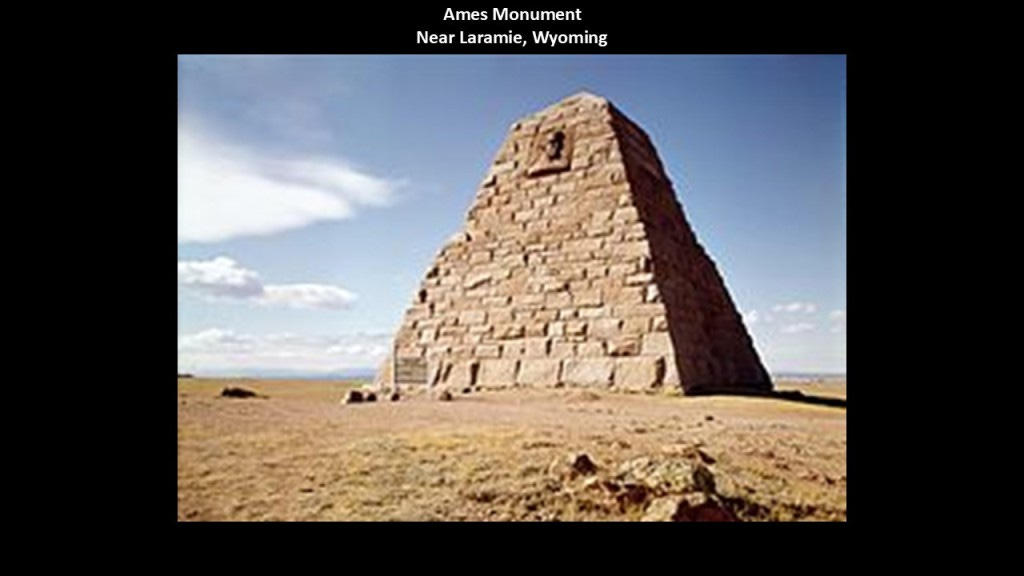
This is the Ames Monument near Laramie in Wyoming.
This large pyramid was said to have been also designed by Henry Hobson Richardson, and built between 1880 and 1882.
It was dedicated to the Ames brothers for their role in financing the Union Pacific Railroad.
The new history of “The Robber Barons and the Reset” seems to have gotten its start in Pennsylvania, where there were a lot of firsts happening in our historical narrative.
The nickname of Pennsylvania is “The Keystone State,” and in its anecdotal history, was said to have come from its location in the keystone of the arch, depicted here, in the center of the original thirteen colonies.

But another reason comes to mind in the definition of “keystone,” in its figurative sense as opposed to its literal meaning as the stone in the middle of the arch which holds up the others.”
The idea of “that which holds together other parts…locking together the whole structure.”
Pennsylvania certainly seems to have played an instrumental role in doing just that in our historical narrative.

Additionally, the story of the Masonic Keystone is well-worth looking at. which has the letters “HTWSSTKS” engraved on it, said to mean “Hiram The Widows Son Sent To King Solomon,” referring to Hiram Abiff.
Hiram Abiff is the main character in an allegory presented to all 3rd-degree Freemasonry candidates as the main architect of Solomon’s Temple.
Hiram Abiff was murdered inside the temple with a mason’s tool by three fellow-craft masons from the workforce, or “ruffians,” after he wouldn’t give them his Master Mason secrets, which were lost with his death.
I found an article on the masonicworld.com website awhile back when I was looking for information on Hiram Abiff.
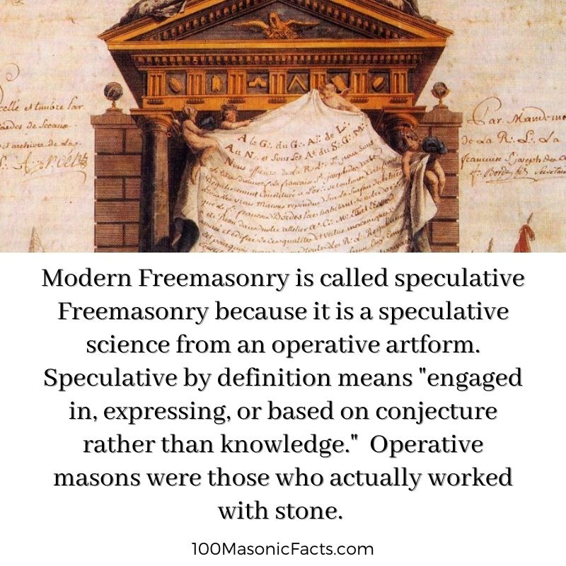
In it, the writer talks about “Operative Masonry” and the beginning of “Speculative Masonry” in 1717, with the founding of the Premier Grand Lodge of England.”
The writer indicates in the article that while some believed that operative masons were also in position of the tragic story of Hiram Abiff, there was no mention of Hiram Abiff in the existing records of Operative Masonry from before that time; that there was no third, or Master Mason Degree as a rite until the Premier Grand Lodge was established in 1717; and that it was likely that the legend of Hiram Abiff was introduced at the time of Freemasonry became a speculative organization.

To me this provides supporting evidence that the ritual of the recital of the death of Hiram Abiff is actually an allegory for what happened to the Moors themselves and their advanced civilization by the unworthy craftsman that has been enshrined in one of their main initiation rites.
It is my understanding that only those initiated into the highest degree of western Freemasonry know directly about the Moors.
And it is no secret within Modern Freemasonry that it is “speculative,” meaning based on conjecture rather than knowledge, as opposed to “operative,” meaning those who actually worked with stone.
The New World’s Controllers stole the identity and legacy of the operative masons, and took us from the “Moorish Divine Movement of the World,” from Antiquity, with the eye on top of the pyramid signifying our pineal gland and our connection to the Creator, to it symbolizing “Big Brother,” and the control of the 13 Bloodline families.

There’s a lot more I could add to our lost history, but this gives you some idea of what has taken place here, and not for our benefit.
